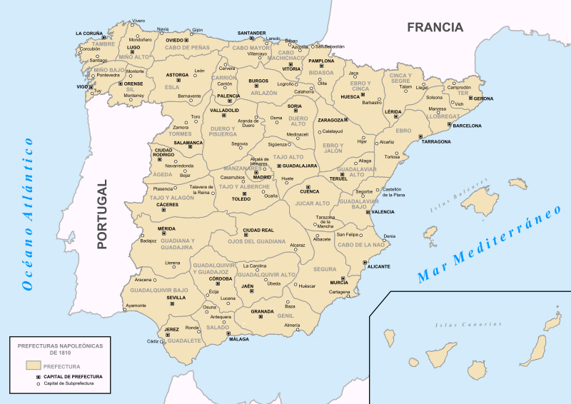
File:Prefecturas Napoleonicas 1810.svg
Appearance

Size of this PNG preview of this SVG file: 800 × 566 pixels. Other resolutions: 320 × 226 pixels | 640 × 453 pixels | 1,024 × 724 pixels | 1,280 × 906 pixels | 2,560 × 1,811 pixels.
Original file (SVG file, nominally 800 × 566 pixels, file size: 1.21 MB)
File history
Click on a date/time to view the file as it appeared at that time.
| Date/Time | Thumbnail | Dimensions | User | Comment | |
|---|---|---|---|---|---|
| current | 14:25, 17 April 2019 |  | 800 × 566 (1.21 MB) | Manarejae | Reverted to version as of 00:13, 3 December 2015 (UTC) |
| 14:17, 17 April 2019 |  | 800 × 566 (1.21 MB) | Manarejae | Montorte corregido por Monforte | |
| 00:13, 3 December 2015 |  | 800 × 566 (1.21 MB) | Ras67 | cropped | |
| 16:21, 24 April 2009 |  | 644 × 458 (1.64 MB) | Mao Zaluchi~commonswiki | {{Information |Description={{en|1=prueba y subo}} {{es|1=prueba y subo}} |Source=trabajo propio (own work) |Author=Mao Zaluchi |Date=2009-04-27 |Permission= |other_versions= }} <!--{{ImageUpload|full}}--> |
File usage
The following 2 pages use this file:
Global file usage
The following other wikis use this file:
- Usage on an.wikipedia.org
- Usage on ast.wikipedia.org
- Usage on es.wikipedia.org
- Historia de la organización territorial de España
- España durante la guerra de la Independencia Española
- Región de León
- Guerra de la Independencia en Valladolid
- Configuración histórica de la provincia de Granada
- Prefectura del Guadalete
- Configuración histórica de la provincia de Jaén
- España napoleónica
- Prefectura del Guadalquivir Alto
- Reinado de José I de España
- Corso Terrestre de Navarra
- Usage on fr.wikipedia.org
- Usage on gl.wikipedia.org
- Usage on pt.wikipedia.org

