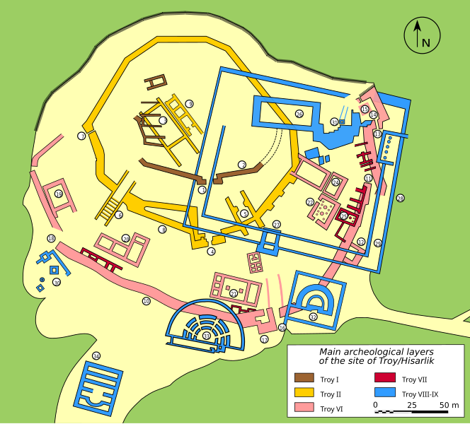
File:Plan Troy-Hisarlik-en.svg
Appearance

Size of this PNG preview of this SVG file: 664 × 599 pixels. Other resolutions: 266 × 240 pixels | 532 × 480 pixels | 851 × 768 pixels | 1,135 × 1,024 pixels | 2,270 × 2,048 pixels | 1,280 × 1,155 pixels.
Original file (SVG file, nominally 1,280 × 1,155 pixels, file size: 146 KB)
File history
Click on a date/time to view the file as it appeared at that time.
| Date/Time | Thumbnail | Dimensions | User | Comment | |
|---|---|---|---|---|---|
| current | 13:38, 8 February 2024 |  | 1,280 × 1,155 (146 KB) | Manlleus | added catalan language |
| 18:47, 28 April 2007 |  | 1,280 × 1,155 (158 KB) | Bibi Saint-Pol | jaune moins fort | |
| 03:19, 5 February 2007 |  | 1,280 × 1,155 (158 KB) | Bibi Saint-Pol | == Description == {{Information| |Description= {{en|Plan of the archeological site of Troy/Hisarlik (see legend below).}} ''Legend:'' {{{!}} {{!}}- {{!}} * 1: Gate * 2: City Wall * 3: Megarons * 4: FN Gate * 5: FO Gate * 6: FM Gate and Ramp * 7: FJ Gate * |
File usage
The following 4 pages use this file:
Global file usage
The following other wikis use this file:
- Usage on ar.wikipedia.org
- Usage on arz.wikipedia.org
- Usage on bg.wikipedia.org
- Usage on ca.wikipedia.org
- Usage on eo.wikipedia.org
- Usage on eu.wikipedia.org
- Usage on fa.wikipedia.org
- Usage on fi.wikipedia.org
- Usage on fr.wikivoyage.org
- Usage on ga.wikipedia.org
- Usage on ha.wikipedia.org
- Usage on he.wikipedia.org
- Usage on hr.wikipedia.org
- Usage on it.wikipedia.org
- Usage on it.wikivoyage.org
- Usage on ja.wikipedia.org
- Usage on la.wikipedia.org
- Usage on mt.wikipedia.org
- Usage on no.wikipedia.org
- Usage on pl.wikipedia.org
- Usage on pt.wikipedia.org
- Usage on ru.wikipedia.org
- Usage on simple.wikipedia.org
- Usage on sl.wikipedia.org
- Usage on sv.wikipedia.org
- Usage on sw.wikipedia.org
- Usage on tl.wikipedia.org
- Usage on ur.wikipedia.org
- Usage on www.wikidata.org
- Usage on zh.wikipedia.org


