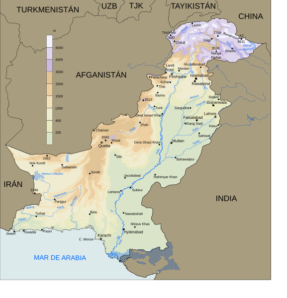
File:Pakistan geography es.svg
Appearance

Size of this PNG preview of this SVG file: 577 × 599 pixels. Other resolutions: 231 × 240 pixels | 462 × 480 pixels | 739 × 768 pixels | 986 × 1,024 pixels | 1,972 × 2,048 pixels | 1,625 × 1,688 pixels.
Original file (SVG file, nominally 1,625 × 1,688 pixels, file size: 650 KB)
File history
Click on a date/time to view the file as it appeared at that time.
| Date/Time | Thumbnail | Dimensions | User | Comment | |
|---|---|---|---|---|---|
| current | 16:05, 16 September 2007 |  | 1,625 × 1,688 (650 KB) | Jarke | {{Information |Description={{es|Mapa de la geografía de Pakistán}} |Source=self-made, helped with Image:Pakistan 2002 CIA map.jpg (PD) |Date=16 Sep 2007 |Author= Jarke |Other version=Image:Pakistan geography en.svg }} == Licensing = |
File usage
The following 2 pages use this file:
Global file usage
The following other wikis use this file:
- Usage on ast.wikipedia.org
- Usage on es.wikipedia.org
- Pakistán
- Usuario:Jarke
- Geografía de Pakistán
- Wikipedia:Candidatos a recursos destacados/Pakistan geography es.svg
- Wikipedia:Recurso del día/enero de 2008
- Wikipedia:Candidatos a recursos destacados/Octubre-2007
- Plantilla:RDD/5
- Wikipedia:Imágenes destacadas/Diagramas, dibujos y mapas
- Wikipedia:Recurso del día/agosto de 2008
- Wikipedia:Recurso del día/1 - 100
- Wikipedia:Recurso del día/diciembre de 2009
- Wikipedia:Recurso del día/junio de 2011
- Wikipedia:Recurso del día/mayo de 2013
- Wikipedia:Recurso del día/diciembre de 2015
- Wikipedia:Recurso del día/marzo de 2018
- Frontera entre Pakistán e India
- Wikipedia:Recurso del día/julio de 2020
- Wikipedia:Recurso del día/junio de 2023


