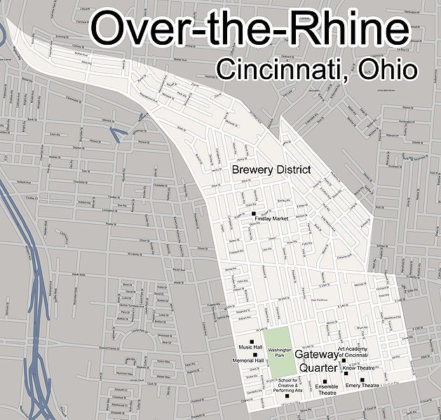
File:Over-the-rhine-map.jpg
Appearance

Size of this preview: 629 × 600 pixels. Other resolutions: 252 × 240 pixels | 503 × 480 pixels | 805 × 768 pixels | 1,074 × 1,024 pixels | 1,876 × 1,789 pixels.
Original file (1,876 × 1,789 pixels, file size: 730 KB, MIME type: image/jpeg)
File history
Click on a date/time to view the file as it appeared at that time.
| Date/Time | Thumbnail | Dimensions | User | Comment | |
|---|---|---|---|---|---|
| current | 01:06, 20 August 2009 |  | 1,876 × 1,789 (730 KB) | Wholtone | More accurate map with more landmarks. |
| 23:26, 15 August 2009 |  | 2,261 × 1,789 (1.15 MB) | Wholtone | Included a few missing streets. | |
| 23:12, 15 August 2009 |  | 2,261 × 1,789 (1.14 MB) | Wholtone | Removed "Pendleton" from map since it is its own neighborhood. | |
| 01:10, 31 July 2008 |  | 2,261 × 1,789 (893 KB) | Wholtone | {{Information |Description=A map of Over-the-Rhine, a Cincinnati neighborhood. Borders are approximate. |Source=http://www.openstreetmap.org/ |Date=July 30, 2008 |Author=Myself, based on http://www.openstreetmap.org map. |Permission={{cc-by-sa-2.0}} |othe | |
| 01:06, 31 July 2008 |  | 2,261 × 1,789 (858 KB) | Wholtone | {{Information |Description={{en|1=A map of Over-the-Rhine, a Cincinnati neighborhood. Borders are approximate.}} |Source=http://www.openstreetmap.org |Author=Myself, with the original map coming from http://www.openstreetmap.org |Date=July 30, 2008 |Permi |
File usage
The following page uses this file:
