Jump to content

File:Organa crater.jpg

Page contents not supported in other languages.
This is a file from the Wikimedia Commons
From Wikipedia, the free encyclopedia

Original file (2,416 × 1,266 pixels, file size: 1.23 MB, MIME type: image/jpeg)

Summary

Description
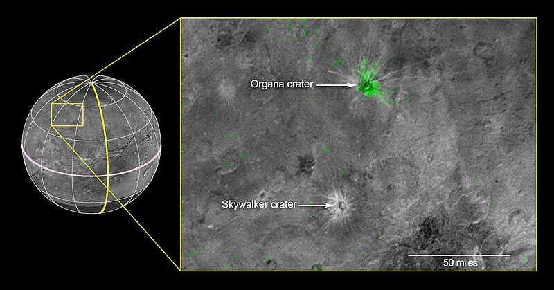
English: This composite image is based on observations from the New Horizons Ralph/LEISA instrument made at 10:25 UT (6:25 a.m. EDT) on July 14, 2015, when New Horizons was 50,000 miles (81,000 kilometers) from Charon. The spatial resolution is 3 miles (5 kilometers) per pixel. The LEISA data were downlinked Oct. 1-4, 2015, and processed into a map of Charon's 2.2 micron ammonia-ice absorption band. Long Range Reconnaissance Imager (LORRI) panchromatic images used as the background in this composite were taken about 8:33 UT (4:33 a.m. EDT) July 14 at a resolution of 0.6 miles (0.9 kilometers) per pixel and downlinked Oct. 5-6. The ammonia absorption map from LEISA is shown in green on the LORRI image. The region covered by the yellow box is 174 miles across (280 kilometers).
Date
Source http://www.nasa.gov/sites/default/files/thumbnails/image/nh-charon_nh3-annotated.jpg
Author NASA/JHUAPL/SwRI

Licensing

Public domain This file is in the public domain in the United States because it was solely created by NASA. NASA copyright policy states that "NASA material is not protected by copyright unless noted". (See Template:PD-USGov, NASA copyright policy page or JPL Image Use Policy.)
Warnings:

Captions

Add a one-line explanation of what this file represents

Items portrayed in this file

depicts

File history

Click on a date/time to view the file as it appeared at that time.

Date/TimeThumbnailDimensionsUserComment
current09:35, 30 October 2015Thumbnail for version as of 09:35, 30 October 20152,416 × 1,266 (1.23 MB)AcagastyaUser created page with UploadWizard

The following page uses this file:

Global file usage

The following other wikis use this file:

Metadata