File:OregonTribes.jpg

Original file (1,478 × 1,454 pixels, file size: 564 KB, MIME type: image/jpeg)
Summary
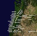
[edit]Approximate geographic location of the First Nations of Oregon and Southern Washington at the time of European settlement in the early 19th Century. Adapted from Carlos A. Schwantes, "Indian Groups in the Pacific Northwest," in The Pacific Northwest: An Interpretive History. Lincoln: University of Nebraska Press, 1989; pg. 31. Created by Tim Davenport ("Carrite") for Wikipedia by superimposing type onto a crop of the public domain NASA "Big Blue Marble" image. Released to the public domain without restriction.
| The uploader or another editor requests that a local copy of this file be kept. This image or media file may be available on the Wikimedia Commons as File:OregonTribes.jpg, where categories and captions may be viewed. While the license of this file may be compliant with the Wikimedia Commons, an editor has requested that the local copy be kept too. This file does not meet CSD F8 and should not be tagged as a Commons duplicate. If you desire to nominate it for deletion, notify the tagging editor. |
Licensing
[edit]| This file is made available under the Creative Commons CC0 1.0 Universal Public Domain Dedication.
The person who associated a work with this deed has dedicated the work to the public domain by waiving all of his or her rights to the work worldwide under copyright law, including all related and neighboring rights, to the extent allowed by law. You can copy, modify, distribute and perform the work, even for commercial purposes, all without asking permission. |
File history
Click on a date/time to view the file as it appeared at that time.
| Date/Time | Thumbnail | Dimensions | User | Comment | |
|---|---|---|---|---|---|
| current | 23:23, 23 September 2012 |  | 1,478 × 1,454 (564 KB) | Carrite (talk | contribs) | Changes Wyam to Tenino, the former a subtribe of the latter, per Hines, "The Forgotten Tribes: Oral Tales of the Teninos and Adjacent Mid-Columbia River Indian Nations,'' pp. 18-20. |
| 15:31, 13 September 2012 |  | 1,478 × 1,454 (759 KB) | Carrite (talk | contribs) | Refining of placement; corrects an error. | |
| 20:05, 12 September 2012 |  | 1,478 × 1,454 (763 KB) | Carrite (talk | contribs) | Approximate geographic location of the First Nations of Oregon and Southern Washington at the time of European settlement in the early 19th Century. Adapted from Carlos A. Schwantes, "Indian Groups in the Pacific Northwest," in ''The Pacific Northwest:... |
You cannot overwrite this file.
File usage
The following page uses this file:
