Jump to content

File:Orbe Europa.png

Page contents not supported in other languages.
This is a file from the Wikimedia Commons
From Wikipedia, the free encyclopedia

Original file (1,250 × 769 pixels, file size: 73 KB, MIME type: image/png)

This map image could be re-created using vector graphics as an SVG file. This has several advantages; see Commons:Media for cleanup for more information. If an SVG form of this image is available, please upload it and afterwards replace this template with {{vector version available|new image name}}.


It is recommended to name the SVG file “Orbe Europa.svg”—then the template Vector version available (or Vva) does not need the new image name parameter.

Summary

Description
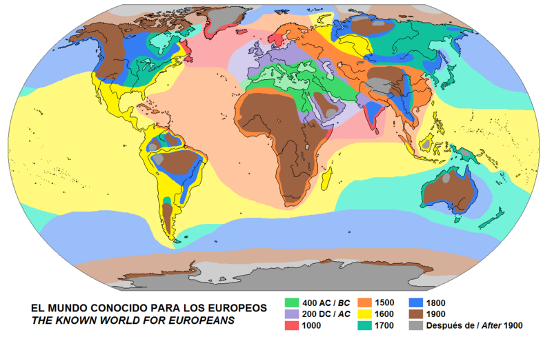
Español: Evolución del conocimiento geográfico desde la perspectiva occidental. Mapa base
English: Evolution of the geographical knowledge from the Western point of view. Base map
Date
Source Own work
Author Universalis

Licensing

I, the copyright holder of this work, hereby publish it under the following license:
w:en:Creative Commons
attribution share alike
This file is licensed under the Creative Commons Attribution-Share Alike 4.0 International license.
You are free:
  • to share – to copy, distribute and transmit the work
  • to remix – to adapt the work
Under the following conditions:
  • attribution – You must give appropriate credit, provide a link to the license, and indicate if changes were made. You may do so in any reasonable manner, but not in any way that suggests the licensor endorses you or your use.
  • share alike – If you remix, transform, or build upon the material, you must distribute your contributions under the same or compatible license as the original.

Captions

Add a one-line explanation of what this file represents

Items portrayed in this file

depicts

31 May 2023

image/png

75,248 byte

769 pixel

1,250 pixel

2f6bdaa6e53c7b4144e00dadfb1669c1a8b298f7

File history

Click on a date/time to view the file as it appeared at that time.

Date/TimeThumbnailDimensionsUserComment
current14:38, 23 October 2024Thumbnail for version as of 14:38, 23 October 20241,250 × 769 (73 KB)Ciaurlecadded northern india to 200DC, other minor changes
14:01, 8 April 2024Thumbnail for version as of 14:01, 8 April 20241,250 × 769 (73 KB)Ciaurlecuniformed to other similar maps
20:13, 31 May 2023Thumbnail for version as of 20:13, 31 May 20231,250 × 769 (68 KB)UniversalisUploaded own work with UploadWizard

The following 2 pages use this file:

Global file usage

The following other wikis use this file:

Metadata