File:NepalKhotangDistrictmap.png
Appearance

Size of this preview: 424 × 600 pixels. Other resolutions: 169 × 240 pixels | 339 × 480 pixels | 543 × 768 pixels | 723 × 1,024 pixels | 2,479 × 3,508 pixels.
Original file (2,479 × 3,508 pixels, file size: 346 KB, MIME type: image/png)
File history
Click on a date/time to view the file as it appeared at that time.
| Date/Time | Thumbnail | Dimensions | User | Comment | |
|---|---|---|---|---|---|
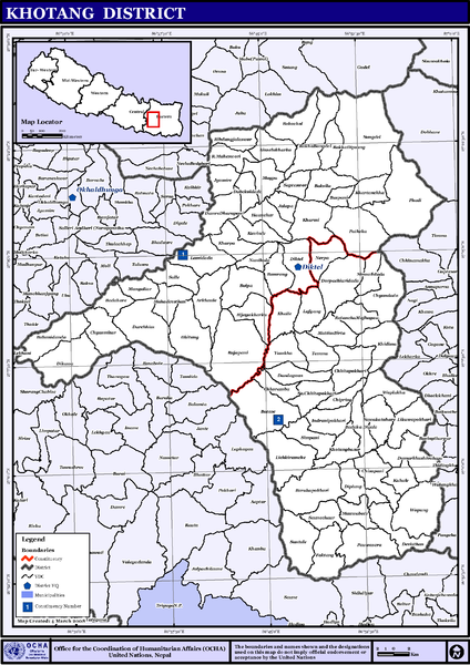
| current | 13:55, 13 November 2008 |  | 2,479 × 3,508 (346 KB) | Sadalmelik | == Summary == {{Information |Description={{en|1=Map displaying Village Development Committees in Khotang District, Nepal}} |Source=http://www.un.org.np/maps/district-maps/eastern/Khotang.pdf |Date=March 4, 2008 |Author=United Nations |Permission= |ot |
File usage
The following 2 pages use this file:
Global file usage
The following other wikis use this file:
- Usage on de.wikipedia.org
- Usage on fi.wikipedia.org
- Usage on hi.wikipedia.org
- Usage on mai.wikipedia.org
- खोटाङ जिला
- दिक्तेल नगरपालिका
- बडहरे
- आकृति:खोटाङ जिलाक गाविससभ
- चिसापानी, खोटाङ
- च्यास्मिटार
- चिहानडाँडा
- छितापोखरी
- छोरम्बु
- जालपा
- ज्यामिरे, खोटाङ
- टेम्मा
- डमर्खुशिवालय
- डाँडागाउँ, खोटाङ
- डिकुवा
- डुम्रे धारापानी
- दिप्लुङ
- दुर्छिम
- दुवेकोलडाँडा
- देविस्थान, खोटाङ
- दोर्पाचिउरीडाँडा
- धितुङ
- निर्मलीडाँडा
- नुनथला
- नेर्पा
- पाथेका
- पौवासेरा
- फाक्टाङ
- फेदी
- बतासे, खोटाङ
- बराहपोखरी
- बाक्सिला
- बासपानी
- बाहुनीडाँडा
- बिजयखर्क
- बुईपा
- मंगलटार
- महादेवस्थान
- महेश्वरी
- माक्पा
- मात्तिमविर्ता
- मौवाबाटे
- याम्खा
- हौंचुर
- सुन्तले
- सुङदेल
View more global usage of this file.

