File:Mozambique2014.png
Appearance

Size of this preview: 427 × 599 pixels. Other resolutions: 171 × 240 pixels | 342 × 480 pixels | 548 × 768 pixels | 730 × 1,024 pixels | 1,461 × 2,048 pixels | 3,924 × 5,501 pixels.
Original file (3,924 × 5,501 pixels, file size: 1.29 MB, MIME type: image/png)
File history
Click on a date/time to view the file as it appeared at that time.
| Date/Time | Thumbnail | Dimensions | User | Comment | |
|---|---|---|---|---|---|
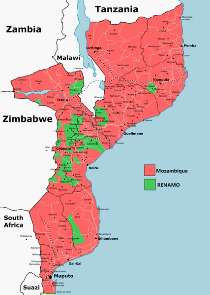
| current | 18:23, 15 May 2024 |  | 3,924 × 5,501 (1.29 MB) | Borysk5 | == {{int:filedesc}} == {{Information |Description=Map of situation in Mozambique in February 2014 |Source=Own work, based on [http://www.redeangola.info/multimedia/mapa-guerra-mocambique/ Mapa do conflito em Moçambique], 12 February 2014 |Date=2024-05-15 |Author=user:Borysk5 |Permission= |other_versions= }} == {{int:license-header}} == {{self|cc-by-sa-all}} Category:Mozambican Civil War Category:RENAMO |
File usage
The following page uses this file:
