Jump to content

File:Markakol map-ru.svg

Page contents not supported in other languages.
This is a file from the Wikimedia Commons
From Wikipedia, the free encyclopedia

Original file (SVG file, nominally 1,278 × 1,949 pixels, file size: 4.22 MB)

Picture of the year
Picture of the year
Featured picture

Wikimedia Commons

This is a featured picture on Wikimedia Commons (Featured pictures) and is considered one of the finest images. See its nomination here.

If you have an image of similar quality that can be published under a suitable copyright license, be sure to upload it, tag it, and nominate it.

Summary

Description
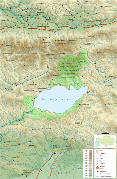
Русский: Карта Маркакольского заповедника
English: Map of Markakol reserve (in Kazakstan) and surrounding area in Russian
Français : Carte topographique (en russe) de la région de la réserve et du lac Markakol au Kazakstan.
SVG development
InfoField
 
The source code of this large SVG is invalid due to an error.
 
This oversized W3C-invalid map was created with Inkscape…important.
 
 This map uses embedded text that can be easily translated using a text editor.
 
  This SVG map uses embedded raster graphics to show its topographic structures.
Date 22 March 2009 (original upload date)
Source Own work
Creator
Georeferencing Georeference the map in Wikimaps Warper If inappropriate please set warp_status = skip to hide.
Other versions


Licensing

I, the copyright holder of this work, hereby publish it under the following licenses:
w:en:Creative Commons
attribution share alike
This file is licensed under the Creative Commons Attribution-Share Alike 3.0 Unported license.
You are free:
  • to share – to copy, distribute and transmit the work
  • to remix – to adapt the work
Under the following conditions:
  • attribution – You must give appropriate credit, provide a link to the license, and indicate if changes were made. You may do so in any reasonable manner, but not in any way that suggests the licensor endorses you or your use.
  • share alike – If you remix, transform, or build upon the material, you must distribute your contributions under the same or compatible license as the original.
GNU head Permission is granted to copy, distribute and/or modify this document under the terms of the GNU Free Documentation License, Version 1.2 or any later version published by the Free Software Foundation; with no Invariant Sections, no Front-Cover Texts, and no Back-Cover Texts. A copy of the license is included in the section entitled GNU Free Documentation License.
You may select the license of your choice.

Captions

Add a one-line explanation of what this file represents

Items portrayed in this file

depicts

File history

Click on a date/time to view the file as it appeared at that time.

Date/TimeThumbnailDimensionsUserComment
current20:59, 21 February 2020Thumbnail for version as of 20:59, 21 February 20201,278 × 1,949 (4.22 MB)JoKalliauerSVGs should only conatain svg/png/jpeg but gif-support limited, see https://www.w3.org/TR/SVG11/struct.html#ImageElement
08:38, 1 April 2009Thumbnail for version as of 08:38, 1 April 20091,278 × 1,949 (5.92 MB)Mikhail2009Исправлена ошибка в Южно-Алтайском хребте
08:24, 1 April 2009Thumbnail for version as of 08:24, 1 April 20091,278 × 1,949 (5.92 MB)Mikhail2009Поправлены шрифты
08:04, 1 April 2009Thumbnail for version as of 08:04, 1 April 20091,278 × 1,949 (5.92 MB)Mikhail2009-
10:26, 22 March 2009Thumbnail for version as of 10:26, 22 March 20091,281 × 1,951 (3.88 MB)Mikhail2009-
10:23, 22 March 2009Thumbnail for version as of 10:23, 22 March 20091,281 × 1,951 (3.88 MB)Mikhail2009{{Information |Description={{ru|1=Карта Маркакольского заповедника}} |Source=Own work by uploader |Author=Mikhail2009 |Date= |Permission= |other_versions= }} <!--{{ImageUpload|full}}--> [[Category:Markak

Global file usage

The following other wikis use this file:

Metadata