File:Mapmaunaloa.png
Appearance
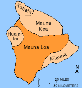
Mapmaunaloa.png (279 × 299 pixels, file size: 4 KB, MIME type: image/png)
File history
Click on a date/time to view the file as it appeared at that time.
| Date/Time | Thumbnail | Dimensions | User | Comment | |
|---|---|---|---|---|---|
| current | 12:52, 24 June 2010 |  | 279 × 299 (4 KB) | Ras67 | cropped and squeezed |
| 06:34, 13 July 2009 |  | 281 × 301 (8 KB) | Falcorian | Lossless compression with pngout. | |
| 14:58, 5 August 2007 |  | 281 × 301 (9 KB) | Hike395 | {{Information |Description={{en|Map showing relationship of Mauna Loa to other volcanoes that form the Big Island of Hawaii} |Source=http://hvo.wr.usgs.gov/maunaloa/ |Date=- |Author=Hawaii Volcano Observatory, USGS |Permission=Public Domain U.S. Governmen |
File usage
The following page uses this file:
Global file usage
The following other wikis use this file:
- Usage on eo.wikipedia.org
- Usage on he.wikipedia.org


