Jump to content

File:MapaAF447 Aeronáutica.jpg

Page contents not supported in other languages.
This is a file from the Wikimedia Commons
From Wikipedia, the free encyclopedia

Original file (1,033 × 1,299 pixels, file size: 394 KB, MIME type: image/jpeg)

Summary

Description
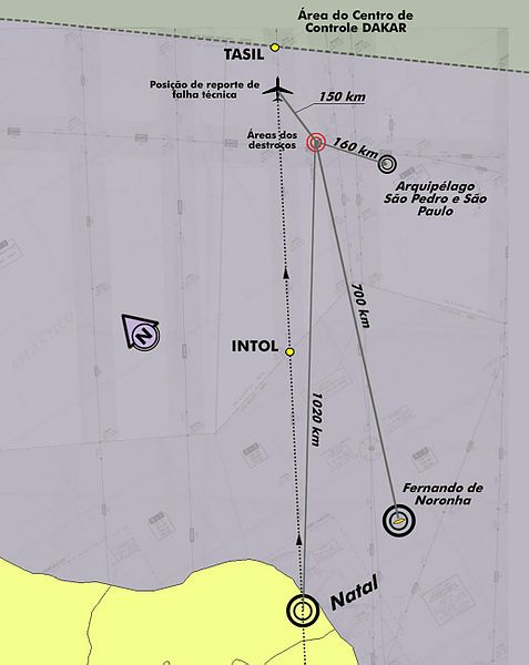
Português: Mapa fornecido pela Aeronáutica que mostra o local onde foram avistados os destroços do avião da Air France e onde se concentram as buscas
English: Map provided by the Brazilian Air Force shows where the wreckage of the Air France plane was sighted, and where they focused their search
Français : La carte fournie par l'armée de l'air brésilienne montre où les débris de l'avion d'Air France ont été aperçus et où elle a concentré ses recherches.
Deutsch: Diese von der brasilianischen Luftwaffe zur Verfügung gestellte Karte zeigt, wo Wrackteile der Air France Maschine gesichtet wurden, und auf welche Bereiche die Suche konzentriert wurde.
Date 2/6/2009
Source Agência Brasil
Author Força Aérea Brasileira
Permission
(Reusing this file)
This photograph was produced by Agência Brasil, a public Brazilian news agency.
Their website (formerly) stated: "Todo o conteúdo deste site está publicado sob a Licença Creative Commons Atribuição 3.0 Brasil exceto quando especificado em contrário e nos conteúdos replicados de outras fontes." (English translation: All content on this website is published under the Creative Commons Attribution 3.0 Brazil License unless specified otherwise and content replicated from other sources.)

This license is not valid for content that was produced (i.e. date taken) by Agência Brasil after 23 February 2017. None of this is to imply that Agência Brasil content produced after 2017 cannot be freely licensed if otherwise noted.
To the uploader: You must provide a link (URL) to the original file and the authorship information if available.
w:en:Creative Commons
attribution
This file is licensed under the Creative Commons Attribution 3.0 Brazil license.
You are free:
  • to share – to copy, distribute and transmit the work
  • to remix – to adapt the work
Under the following conditions:
  • attribution – You must give appropriate credit, provide a link to the license, and indicate if changes were made. You may do so in any reasonable manner, but not in any way that suggests the licensor endorses you or your use.

Captions

Add a one-line explanation of what this file represents

Items portrayed in this file

depicts

File history

Click on a date/time to view the file as it appeared at that time.

Date/TimeThumbnailDimensionsUserComment
current16:29, 3 June 2009Thumbnail for version as of 16:29, 3 June 20091,033 × 1,299 (394 KB)Alexanderps{{Information |Description={{pt|1=Mapa fornecido pela Aeronáutica que mostra o local onde foram avistados os destroços do avião da Air France e onde se concentram as buscas}} |Source=[http://www.agenciabrasil.gov.br/media/imagens/2009/06/03/1025mapa000
No pages on the English Wikipedia use this file (pages on other projects are not listed).

Metadata