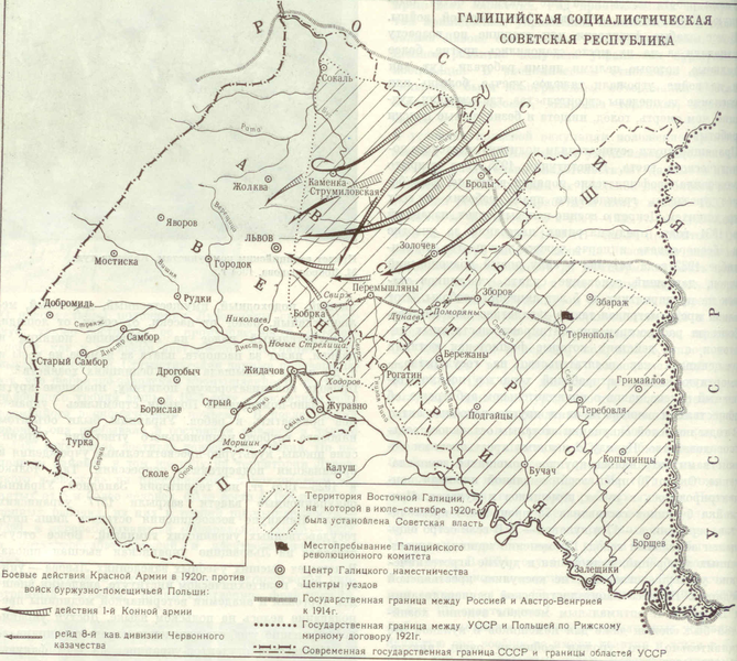
File:MapGSSR cr.png
Appearance

Size of this preview: 669 × 600 pixels. Other resolutions: 268 × 240 pixels | 536 × 480 pixels | 857 × 768 pixels | 1,143 × 1,024 pixels | 1,958 × 1,755 pixels.
Original file (1,958 × 1,755 pixels, file size: 3.49 MB, MIME type: image/png)
File history
Click on a date/time to view the file as it appeared at that time.
| Date/Time | Thumbnail | Dimensions | User | Comment | |
|---|---|---|---|---|---|
| current | 07:30, 24 June 2011 |  | 1,958 × 1,755 (3.49 MB) | Mcowkin | {{Information |Description ={{ru|1=Скан иллюстрации из книги "История городов и сел УССР" Львовская область.Главная редакция украинской советской энцикл |
File usage
The following page uses this file:
Global file usage
The following other wikis use this file:
- Usage on ar.wikipedia.org
- Usage on ast.wikipedia.org
- Usage on be-tarask.wikipedia.org
- Usage on be.wikipedia.org
- Usage on es.wikipedia.org
- Usage on eu.wikipedia.org
- Usage on fi.wikipedia.org
- Usage on fr.wikipedia.org
- Usage on gl.wikipedia.org
- Usage on hu.wikipedia.org
- Usage on id.wikipedia.org
- Usage on it.wikipedia.org
- Usage on pl.wikipedia.org
- Usage on ro.wikipedia.org
- Usage on rue.wikipedia.org
- Usage on ru.wikipedia.org
- Usage on uk.wikipedia.org
- Usage on www.wikidata.org
