Jump to content

File:Magre (fleuve).png

Page contents not supported in other languages.
This is a file from the Wikimedia Commons
From Wikipedia, the free encyclopedia

Magre_(fleuve).png (360 × 499 pixels, file size: 244 KB, MIME type: image/png)

Summary

Description
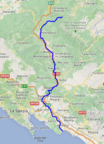
Français : carte réalisée sur umap
Italiano: Fiume Magra.
Deutsch: Karte des Flussverlaufs der Magra mit Mündung ins Meer (unten Mitte). Die Küstenlinie östlich der Flussmündung unterhalb von Carrara (beschriftet) folgt der Flussrichtung fast in die rechte untere Bildecke. Die orange eingezeichnete Küstenautobahn Autostrada A 12 begleitet von der Küste her zunächst den Fluss Magra flussaufwärts, dann die zufliessende Vara ohne wesentlich die Richtung zu ändern. Am Zufluss der Vara als rechter Nebenfluss (im unteren Drittel der Karte) ändert die Magra an dieser Stelle aus dem Apennin von Aulla her kommend also ihren Verlauf um fast 90 Grad von Norden her nach Südost. Etwas weiter flussaufwärts dieses Zusammenflusses ist ein gewundener Verlauf vor dem Durchbruch in die Tiefebene mit mehreren unterschiedlich starken Biegungen zu erkennen, also unterhalb der Beschriftung für den Hauptort der Gemeinde Aulla. Bei Aulla und bei Pontremoli gibt es weit weniger stark ausgeprägte Richtungswechsel. Im Tal der Magra (Val di Magra) flussaufwärts des Richtungswechsels verläuft die A15 (ein Autobahnkreuz) von der Küstenstadt La Spezia her (links unten mit einem kleinen hellgrünen Punkt am Golfo dei Poeti markiert) sowie weitere in gelb nicht ganz so deutlich sichtbare Strassen, auch die Eisenbahnlinie von La Spezia nach Norden (Ferrovia Pontremolese), die in der Karte überhaupt nicht gut sichtbar in blassgrau in den graugrünen Hintergrund eingezeichnet ist. Die in der Karte diagonal von links oben nach rechts unten verlaufenden nur schwach angedeuteten Gebirgsrücken (Alpi Apuane bei Carrara) trennen als "Promontorio" oder Halbinsel sowohl die Bucht bei La Spezia vom Mittelmeer aber auch das lange Tal mit den Flüssen Magra und Vara (hellgrau) von der Küstenlinie bei Lerici und Ameglia (grün bewaldeter Höhenzug) ab.
Date
Source umap.openstreetmap.fr
Author
Description
This map was created from OpenStreetMap project data, collected by the community. This map may be incomplete, and may contain errors. Don't rely solely on it for navigation.
Date (see file history)
Source openstreetmap.org
Creator
OpenStreetMap contributors
Permission
(Reusing this file)

OpenStreetMap data is available under the Open Database License (details). Map tiles are licensed under the Creative Commons Attribution-ShareAlike 2.0 license (CC-BY-SA 2.0).

This work contains information from OpenStreetMap, which is made available under the Open Database License (ODbL).

The ODbL does not require any particular license for maps produced from ODbL data. Prior to 1 August 2020, map tiles produced by the OpenStreetMap Foundation were licensed under the CC-BY-SA-2.0 license. Maps produced by other people may be subject to other licences.

w:en:Creative Commons
attribution share alike
This file is licensed under the Creative Commons Attribution-Share Alike 2.0 Generic license.
You are free:
  • to share – to copy, distribute and transmit the work
  • to remix – to adapt the work
Under the following conditions:
  • attribution – You must give appropriate credit, provide a link to the license, and indicate if changes were made. You may do so in any reasonable manner, but not in any way that suggests the licensor endorses you or your use.
  • share alike – If you remix, transform, or build upon the material, you must distribute your contributions under the same or compatible license as the original.
Georeferencing Georeference the map in Wikimaps Warper If inappropriate please set warp_status = skip to hide.

Licensing

w:en:Creative Commons
attribution share alike
This file is licensed under the Creative Commons Attribution-Share Alike 4.0 International license.
You are free:
  • to share – to copy, distribute and transmit the work
  • to remix – to adapt the work
Under the following conditions:
  • attribution – You must give appropriate credit, provide a link to the license, and indicate if changes were made. You may do so in any reasonable manner, but not in any way that suggests the licensor endorses you or your use.
  • share alike – If you remix, transform, or build upon the material, you must distribute your contributions under the same or compatible license as the original.

Captions

Course of Magra river, Italy

Items portrayed in this file

depicts

7 April 2020

image/png

File history

Click on a date/time to view the file as it appeared at that time.

Date/TimeThumbnailDimensionsUserComment
current18:24, 7 April 2020Thumbnail for version as of 18:24, 7 April 2020360 × 499 (244 KB)CcmpgUploaded a work by {{openstreetmap}} from umap.openstreetmap.fr with UploadWizard

The following 2 pages use this file:

Global file usage

The following other wikis use this file: