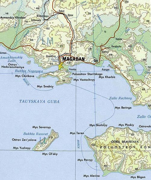
File:Magadan 1978.jpg
Appearance

Size of this preview: 501 × 599 pixels. Other resolutions: 201 × 240 pixels | 401 × 480 pixels | 652 × 780 pixels.
Original file (652 × 780 pixels, file size: 160 KB, MIME type: image/jpeg)
File history
Click on a date/time to view the file as it appeared at that time.
| Date/Time | Thumbnail | Dimensions | User | Comment | |
|---|---|---|---|---|---|
| current | 05:59, 28 September 2015 |  | 652 × 780 (160 KB) | Kaliforniyka | rotate and crop |
| 19:16, 4 March 2006 |  | 746 × 871 (184 KB) | Maksim | La bildo estas kopiita de wikipedia:en. La originala priskribo estas: '''Subject''': Magadan area of far east Russia '''Source''': Portion of Magadan sheet. Topographic Map NO 56, Series 1301. Original Scale 1:1,000,000. Printed by U.S. Defense Mapping |
File usage
The following 8 pages use this file:
Global file usage
The following other wikis use this file:
- Usage on az.wikipedia.org
- Usage on be.wikipedia.org
- Usage on bg.wikipedia.org
- Usage on ca.wikipedia.org
- Usage on ceb.wikipedia.org
- Usage on es.wikipedia.org
- Usage on fr.wikipedia.org
- Usage on he.wikipedia.org
- Usage on hr.wikipedia.org
- Usage on hy.wikipedia.org
- Usage on it.wikipedia.org
- Usage on ja.wikipedia.org
- Usage on nl.wikipedia.org
- Usage on nn.wikipedia.org
- Usage on oc.wikipedia.org
- Usage on pl.wiktionary.org
- Usage on pms.wikipedia.org
- Usage on pt.wikipedia.org
- Usage on ru.wikipedia.org
View more global usage of this file.


