Jump to content

File:Location of the BOTs.png

Page contents not supported in other languages.
This is a file from the Wikimedia Commons
From Wikipedia, the free encyclopedia

Location_of_the_BOTs.png (735 × 433 pixels, file size: 100 KB, MIME type: image/png)

Summary

Description
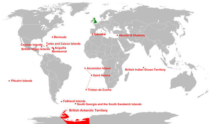
English: Location of the British Overseas Territories (red), Crown dependencies (blue), and Great Britain and Northern Ireland (green)

Crown dependencies:

1. Isle of Man

2. Channel Islands

Date 16:45, 20 April 2007
Source

Brown, Judith (1998) The Twentieth Century, The Oxford History of the British Empire Volume IV, Oxford University Press, pp. 695 ISBN: 0199246793. This file was derived from:

Author Signsolid, RaviC, Richardprins
Other versions
File:Location of the BOTs.svg is a vector version of this file. It should be used in place of this PNG file when not inferior.

File:Location of the BOTs.png → File:Location of the BOTs.svg

For more information, see Help:SVG.

In other languages
Alemannisch  العربية  беларуская (тарашкевіца)  български  বাংলা  català  нохчийн  čeština  dansk  Deutsch  Ελληνικά  English  British English  Esperanto  español  eesti  euskara  فارسی  suomi  français  Frysk  galego  Alemannisch  עברית  hrvatski  magyar  հայերեն  Bahasa Indonesia  Ido  italiano  日本語  ქართული  한국어  lietuvių  македонски  മലയാളം  Bahasa Melayu  norsk bokmål  Plattdüütsch  Nederlands  norsk nynorsk  norsk  occitan  polski  prūsiskan  português  português do Brasil  română  русский  sicilianu  Scots  slovenčina  slovenščina  српски / srpski  svenska  தமிழ்  ไทย  Türkçe  татарча / tatarça  українська  vèneto  Tiếng Việt  中文  中文(中国大陆)  中文(简体)  中文(繁體)  中文(马来西亚)  中文(新加坡)  中文(臺灣)  中文(臺灣)  +/−
New SVG image

Licensing

Public domain This work has been released into the public domain by its author, Signsolid at English Wikipedia. This applies worldwide.
In some countries this may not be legally possible; if so:
Signsolid grants anyone the right to use this work for any purpose, without any conditions, unless such conditions are required by law.

Captions

Add a one-line explanation of what this file represents

Items portrayed in this file

depicts

image/png

File history

Click on a date/time to view the file as it appeared at that time.

(newest | oldest) View (newer 10 | ) (10 | 20 | 50 | 100 | 250 | 500)
Date/TimeThumbnailDimensionsUserComment
current10:20, 29 April 2015Thumbnail for version as of 10:20, 29 April 2015735 × 433 (100 KB)CarnbyMistake
10:18, 29 April 2015Thumbnail for version as of 10:18, 29 April 2015787 × 433 (102 KB)CarnbySouth Sudan
15:48, 23 January 2011Thumbnail for version as of 15:48, 23 January 2011735 × 433 (106 KB)Malus CatulusTypo fix
15:14, 23 January 2011Thumbnail for version as of 15:14, 23 January 2011735 × 433 (106 KB)Malus CatulusWe be using the ol' wench Arial againe, Arrr
12:48, 23 January 2011Thumbnail for version as of 12:48, 23 January 2011735 × 433 (106 KB)Malus CatulusPNG of the SVG version
18:02, 23 August 2010Thumbnail for version as of 18:02, 23 August 2010750 × 430 (88 KB)RaviCgrouped s.atlantic territories to show constitutional change from 2009
12:09, 16 April 2010Thumbnail for version as of 12:09, 16 April 2010750 × 430 (88 KB)RaviCadded mainland UK into the map, since it is now at the beggining of the UK article.
09:16, 24 August 2008Thumbnail for version as of 09:16, 24 August 2008750 × 430 (88 KB)RaviCReverted as [http://commons.wikimedia.org/wiki/User_talk:Samulili#Location_of_the_BOTs.png explained here]
21:40, 23 August 2008Thumbnail for version as of 21:40, 23 August 2008750 × 430 (88 KB)Samulilidifferent image should have different name
16:48, 23 August 2008Thumbnail for version as of 16:48, 23 August 2008750 × 430 (88 KB)RaviC{{Information |Description= |Source= |Date= |Author= |Permission= |other_versions= }}
(newest | oldest) View (newer 10 | ) (10 | 20 | 50 | 100 | 250 | 500)

Global file usage

The following other wikis use this file:

View more global usage of this file.

Metadata