File:LocationCaribbean.png
Appearance
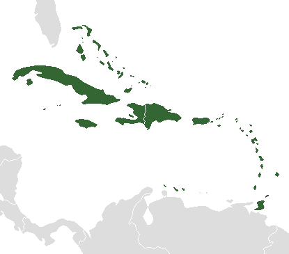
LocationCaribbean.png (415 × 365 pixels, file size: 3 KB, MIME type: image/png)
File history
Click on a date/time to view the file as it appeared at that time.
| Date/Time | Thumbnail | Dimensions | User | Comment | |
|---|---|---|---|---|---|
| current | 02:11, 7 April 2007 |  | 415 × 365 (3 KB) | David Kernow~commonswiki | en:Image:BlankMap-Caribbean.png with Caribbean countries and territories in dark green. Licensing as per Image:BlankMap-Caribbean.png (GFDL). |
File usage
The following 2 pages use this file:
Global file usage
The following other wikis use this file:
- Usage on es.wikipedia.org
- Usage on eu.wikipedia.org
- Usage on fa.wikipedia.org
- Usage on frr.wikipedia.org
- Antiigua an Barbuuda
- Vorlage:Lunen uun a Kariibik
- Bahaamas
- Barbaados
- Domiinika
- Dominikaans Republiik
- Haiti
- Grenaada
- Jamaika
- Kuuba
- St. Kitts an Nevis
- St. Lucia
- St. Vincent an a Grenadiinen
- Trinidad an Tobaago
- Puerto Riko
- Amerikoonsk Jongfoomen Eilunen
- Anguilla
- Montserrat
- Sint Maarten
- Curaçao
- Aruuba
- Bonaire
- Sint Eustatius
- Saaba
- Neederluns Antilen
- Martinique
- Britisk Jongfoomen Eilunen
- Corn Islands
- Guadeloupe
- Turks an Caicos Eilunen
- Kaiman Eilunen
- Navassa
- St. Barths
- San Andres an Providencia
- Usage on fr.wikipedia.org
- Usage on fr.wikinews.org
View more global usage of this file.


