Jump to content

File:Lebanese insurgency.png

Page contents not supported in other languages.
This is a file from the Wikimedia Commons
From Wikipedia, the free encyclopedia

Original file (1,748 × 2,012 pixels, file size: 246 KB, MIME type: image/png)

Summary

File:Lebanese insurgency.svg is a vector version of this file. It should be used in place of this PNG file.

File:Lebanese insurgency.png → File:Lebanese insurgency.svg

For more information, see Help:SVG.

In other languages
Alemannisch  العربية  беларуская (тарашкевіца)  български  বাংলা  català  нохчийн  čeština  dansk  Deutsch  Ελληνικά  English  British English  Esperanto  español  eesti  euskara  فارسی  suomi  français  Frysk  galego  Alemannisch  עברית  hrvatski  magyar  հայերեն  Bahasa Indonesia  Ido  italiano  日本語  ქართული  한국어  lietuvių  македонски  മലയാളം  Bahasa Melayu  norsk bokmål  Plattdüütsch  Nederlands  norsk nynorsk  norsk  occitan  polski  prūsiskan  português  português do Brasil  română  русский  sicilianu  Scots  slovenčina  slovenščina  српски / srpski  svenska  தமிழ்  ไทย  Türkçe  татарча / tatarça  українська  vèneto  Tiếng Việt  中文  中文(中国大陆)  中文(简体)  中文(繁體)  中文(马来西亚)  中文(新加坡)  中文(臺灣)  中文(臺灣)  +/−
New SVG image

Description
Русский: Карта Ливанского конфликта
 
Территории под контролем Ливанских федеральных сил
 
Контролируется Хезболлой
 
Территория, контролируемая террористами т.н. ИГИЛ
 
Контролируется боевиками т.н. Фронта ан-Нусра
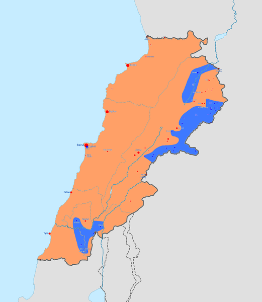
English: Map of the Lebanese insurgency. After updating this map, please also update the date(s) at w:Module:Iraq Syria map date, used to denote the date in articles.
 
Controlled by the Lebanese Government
 
Controlled by Hezbollah
 
Controlled by the Islamic State of Iraq and the Levant (ISIL)
 
Controlled by Tahrir al-Sham (HTS) and Sunni militants
فارسی: نقشهٔ درگیری‌های لبنان
 
در دست دولت لبنان
 
در دست داعش
 
در دست جبههٔ نصرت
Date
Source

Own work

w:en:Template:Lebanese insurgency detailed map
Author BlueHypercane761
Other versions
Ongoing armed conflicts ( Countries Maps )
National or regional Maps of ongoing insurgencies, armed conflicts, disputes of territories, military conflicts, and also current civil or international wars :

Overview Maps:

National-wide Maps:

National-wide Maps of areas of activity:

Note: Comments "areas of activity" means that this is not territorial control is shown.

Sub-national-wide Maps:

See also:
Category:Conflicts in 2024 (with list of countries in ongoing armed conflicts)
Template:City maps of ongoing civil wars (Local maps)

Licensing

I, the copyright holder of this work, hereby publish it under the following license:
w:en:Creative Commons
attribution share alike
This file is licensed under the Creative Commons Attribution-Share Alike 4.0 International license.
You are free:
  • to share – to copy, distribute and transmit the work
  • to remix – to adapt the work
Under the following conditions:
  • attribution – You must give appropriate credit, provide a link to the license, and indicate if changes were made. You may do so in any reasonable manner, but not in any way that suggests the licensor endorses you or your use.
  • share alike – If you remix, transform, or build upon the material, you must distribute your contributions under the same or compatible license as the original.

Captions

Add a one-line explanation of what this file represents

Items portrayed in this file

depicts

5 June 2015

File history

Click on a date/time to view the file as it appeared at that time.

(newest | oldest) View (newer 10 | ) (10 | 20 | 50 | 100 | 250 | 500)
Date/TimeThumbnailDimensionsUserComment
current02:09, 7 March 2019Thumbnail for version as of 02:09, 7 March 20191,748 × 2,012 (246 KB)BlueHypercane761Updated map for the end of the ISIL/al-Qaeda insurgency. The information is current, as of mid-December 2018.
23:26, 9 June 2017Thumbnail for version as of 23:26, 9 June 20171,748 × 2,012 (242 KB)BlueHypercane7616-9-2017 Update. Both ISIL and Tahrir al-Sham/Nusra have lost have of their respective territories. The jihadi forces have also turned on each other.
07:06, 16 October 2015Thumbnail for version as of 07:06, 16 October 20151,748 × 2,012 (237 KB)BlueHypercane761Fixing color errors in the al-Nusra controlled area.
06:26, 21 September 2015Thumbnail for version as of 06:26, 21 September 20151,748 × 2,012 (237 KB)BlueHypercane761Fix.
23:45, 20 September 2015Thumbnail for version as of 23:45, 20 September 20151,748 × 2,012 (237 KB)BlueHypercane7619-21-2015 Update. ISIL has been driven back from the border crossing, but ISIL has also seized control of the Syrian-Lebanese border to the east of Arsal.
10:21, 19 September 2015Thumbnail for version as of 10:21, 19 September 20153,496 × 3,968 (827 KB)BiglesReverted to version as of 09:52, 29 August 2015
19:16, 30 August 2015Thumbnail for version as of 19:16, 30 August 20151,748 × 2,012 (237 KB)BlueHypercane7618-30-2015 Update. Protests have broken out in Beirut over the trash crisis. Also, the reports of ISIL seizing the Syrian border region was labeled as "unconfirmed."
09:52, 29 August 2015Thumbnail for version as of 09:52, 29 August 20153,496 × 3,968 (827 KB)Biglesupdate 29.08.2015
03:24, 21 August 2015Thumbnail for version as of 03:24, 21 August 20151,748 × 2,012 (236 KB)BlueHypercane761Trying out yet another color.
20:03, 26 July 2015Thumbnail for version as of 20:03, 26 July 20151,748 × 2,012 (236 KB)BlueHypercane761Fix.
(newest | oldest) View (newer 10 | ) (10 | 20 | 50 | 100 | 250 | 500)
No pages on the English Wikipedia use this file (pages on other projects are not listed).