Jump to content

File:Landsat 8 launch.jpg

Page contents not supported in other languages.
This is a file from the Wikimedia Commons
From Wikipedia, the free encyclopedia

Original file (2,400 × 3,000 pixels, file size: 994 KB, MIME type: image/jpeg)

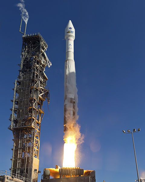
Description VANDENBERG AFB, Calif. -- The Landsat Data Continuity Mission spacecraft lifted off on 11 February 2013 at 1:02 p.m. EST (10:02 a.m. PST, 18:02 UTC) atop a United Launch Alliance Atlas V rocket from Space Launch Complex 3 at California's Vandenberg Air Force Base. The Landsat Data Continuity Mission LDCM is the future of Landsat satellites. It will continue to obtain valuable data and imagery to be used in agriculture, education, business, science, and government. The Landsat Program provides repetitive acquisition of high resolution multispectral data of the Earth's surface on a global basis. The data from the Landsat spacecraft constitute the longest record of the Earth's continental surfaces as seen from space. It is a record unmatched in quality, detail, coverage, and value. For more information, visit: http://www.nasa.gov/mission_pages/landsat/main/index.html
Date Taken on 11 February 2013, 18:02
Source http://mediaarchive.ksc.nasa.gov/detail.cfm?mediaid=64296 (archive link); see also https://images.nasa.gov/details/2013-1435
Author United Launch Alliance/Patrick H. Corkery
Permission
(Reusing this file)
Per source: "No copyright protection is asserted for this photograph. If a recognizable person appears in this photograph, use for commercial purposes may infringe a right of privacy or publicity. It may not be used to state or imply the endorsement by NASA employees of a commercial product, process or service, or used in any other manner that might mislead. Accordingly, it is requested that if this photograph is used in advertising and other commercial promotion, layout and copy be submitted to NASA prior to release."
This image or video was catalogued by Kennedy Space Center of the United States National Aeronautics and Space Administration (NASA) under Photo ID: KSC-2013-1435.

This tag does not indicate the copyright status of the attached work. A normal copyright tag is still required. See Commons:Licensing.
Other languages:

Licensing

Public domain This work has been released into the public domain by its author, United Launch Alliance/Patrick H. Corkery. This applies worldwide.
In some countries this may not be legally possible; if so:
United Launch Alliance/Patrick H. Corkery grants anyone the right to use this work for any purpose, without any conditions, unless such conditions are required by law.

Captions

Add a one-line explanation of what this file represents

Items portrayed in this file

depicts

12 February 2013

File history

Click on a date/time to view the file as it appeared at that time.

Date/TimeThumbnailDimensionsUserComment
current14:15, 12 February 2013Thumbnail for version as of 14:15, 12 February 20132,400 × 3,000 (994 KB)WDGraham{{Information |Description=VANDENBERG AFB, Calif. -- The Landsat Data Continuity Mission spacecraft lifted off at 1:02 p.m. EST, 10:02 a.m. PST) <nowiki>[</nowiki>''sic''<nowiki>]</nowiki> atop a United Launch Alliance Atlas V rocket fr...

The following 2 pages use this file:

Global file usage

The following other wikis use this file: