Jump to content

File:Lake Grand-Lieu SPOT 1249.jpg

Page contents not supported in other languages.
This is a file from the Wikimedia Commons
From Wikipedia, the free encyclopedia

Lake_Grand-Lieu_SPOT_1249.jpg (500 × 500 pixels, file size: 127 KB, MIME type: image/jpeg)

Summary

Description
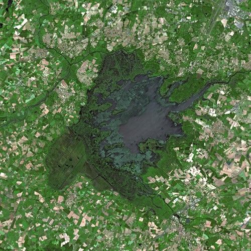
Français : lac de Grand-Lieu vu de satellite, par SPOT ; Ce lac est situé à une dizaine de kilomètres au sud de la Loire. Il occupe une cuvette de faible dénivelé et profondeur. Il n'a donc qu'une faible hauteur d'eau (1.60m d'eau en moyenne en été, et environ 4m au max. en hiver). Sa superficie double en hiver (passant d'environ 35 km² en été à 65 km² en hiver), ce qui explique d'importantes spécificités écologiques. Le lac abrite notamment des forêts flottantes appelées levis, et il est écologiquement fortement inter-relié aux marais et prairies inondables périphériques, recouverts ou non suivant la saison.
English: lac de Grand-Lieu see from satellite by SPOT ; This lake is located in west of France, at about ten kilometers south of Loire. It occupies a basin of low altitude and low depth. It is therefore only low water level (1.60m of water on average in summer, and about 4m max. In winter). Its size doubles in winter (from about 35 sq km in summer to 65 sq km in winter), which explains important ecological characteristics. The lake supports floating forests locally called levis, and it is ecologically highly inter-connected to the near marshes
Date
Source http://gallery.spotimage.com/product_info.php?products_id=1249
Author Cnes - Spot Image
Permission
(Reusing this file)

Removed Watermark: (c) Cnes - Distribution Spot Image

[[Category:Lakes of Loire-Atlantique]}

Licensing

I, the copyright holder of this work, hereby publish it under the following license:
w:en:Creative Commons
attribution share alike
This file is licensed under the Creative Commons Attribution-Share Alike 3.0 Unported license.
You are free:
  • to share – to copy, distribute and transmit the work
  • to remix – to adapt the work
Under the following conditions:
  • attribution – You must give appropriate credit, provide a link to the license, and indicate if changes were made. You may do so in any reasonable manner, but not in any way that suggests the licensor endorses you or your use.
  • share alike – If you remix, transform, or build upon the material, you must distribute your contributions under the same or compatible license as the original.


Textual information (e.g. timestamp) once visible in the image itself has been moved into the image metadata and/or image description page. This makes the image easier to reuse and more language-neutral, and makes the text easier to process and search for. Commons discourages placing visible textual information in images. All licenses accepted on Commons permit this type of modification as a derivative work. If attribution information were removed and the image is not public domain, replace this tag with {{Attribution metadata from licensed image}}.

беларуская (тарашкевіца)‎ | català | Deutsch | English | español | فارسی | français | galego | magyar | italiano | македонски | മലയാളം | português | русский | sicilianu | slovenščina | svenska | Indonesia | 中文 | +/−

Captions

Add a one-line explanation of what this file represents

Items portrayed in this file

depicts

File history

Click on a date/time to view the file as it appeared at that time.

Date/TimeThumbnailDimensionsUserComment
current04:13, 12 July 2008Thumbnail for version as of 04:13, 12 July 2008500 × 500 (127 KB)Jarekt{{Information |Description=Cropped watermark |Source= |Date= |Author= |Permission= |other_versions= }}
13:25, 11 April 2008Thumbnail for version as of 13:25, 11 April 2008500 × 500 (150 KB)Spot Image{{Information |Description=Lake Grand-Lieu by SPOT Satellite |Source=http://gallery.spotimage.com/product_info.php?products_id=1249 |Date=2004 |Author= Cnes - Spot Image |Permission= |other_versions= }} [[Category:SPOT satellite image

The following page uses this file:

Global file usage

Metadata