Jump to content

File:Khanty Mansi dialects.svg

Page contents not supported in other languages.
This is a file from the Wikimedia Commons
From Wikipedia, the free encyclopedia

Original file (SVG file, nominally 1,200 × 757 pixels, file size: 262 KB)

Summary

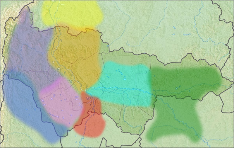
Description
Bahasa Indonesia: Bahasa Khanty:
  • Kelompok (Khanty) Barat
     
    Obdorsk
     
    Ob
     
    Irtysh
  • Kelompok (Khanty) Timur
     
    Surgut
     
    Vakh-Vasyugan
  • Bahasa Mansi
     
    Sosva dan Lyapin
     
    Konda
     
    Tavda, Pelym dan Lozva (semuanya punah)
English: Map of Khanty language varieties:
  • Western (Khanty) group
     
    Obdorsk
     
    Ob
     
    Irtysh
  • Eastern (Kantyk) group
     
    Surgut
     
    Vakh-Vasyugan
  • The Mansi language
     
    Sosva and Lyapin
     
    Konda
     
    Tavda, Pelym and Lozva (all extinct)
  • Русский: Хантыйский язык:
  • Западное (хантыйское) наречие
     
    Обдорский (приуральский)
     
    Приобский
     
    Прииртышский
  • Восточное (кантыкское) наречие
     
    Сургутский
     
    Вах-васюганский
  • Мансийский язык
     
    Сосьвинский и ляпинский
     
    Кондинский
     
    Тавдинский, пелымский, лозьвинский (все исчезнувшие)
  • Date
    Source
    • Основы финно-угорского языкознания / ИЯ АН СССР. — Т. 3. — М.: Наука, 1976. — С. 231—233, 243—247.
      • =The Fundamentals of Fenno-Ugric linguistics. (The Academy of Sciences of the USSR.) Vol. 3. Moscow: Nauka, 1976. PP. 231—233, 243—247.
    • File:Relief_Map_of_Khanty-Mansi_AO.jpg
    Author Любослов Езыкин
    SVG development
    InfoField
     
    The SVG code is valid.
     
    This vector image was created with Inkscape.
     
      This SVG map uses embedded raster graphics to show its topographic structures.

    Licensing

    Public domain This map is ineligible for copyright and therefore in the public domain, because it consists entirely of information that is common property and contains no original authorship. For more information, see Commons:Threshold of originality § Maps.

    English | Español | Galego | Română | slovenščina | العربية | 简体中文 | 繁體中文 | +/−

    Captions

    Add a one-line explanation of what this file represents

    Éléments décrits dans ce fichier

    depicts

    13 June 2015

    File history

    Click on a date/time to view the file as it appeared at that time.

    Date/TimeThumbnailDimensionsUserComment
    current15:11, 13 June 2015Thumbnail for version as of 15:11, 13 June 20151,200 × 757 (262 KB)Любослов ЕзыкинUser created page with UploadWizard

    The following page uses this file:

    Global file usage

    The following other wikis use this file:

    Metadata