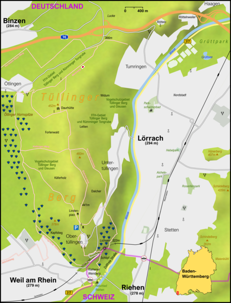
File:Karte Tüllinger Berg.png
Appearance

Size of this preview: 457 × 599 pixels. Other resolutions: 183 × 240 pixels | 366 × 480 pixels | 586 × 768 pixels | 781 × 1,024 pixels | 2,150 × 2,818 pixels.
Original file (2,150 × 2,818 pixels, file size: 3.02 MB, MIME type: image/png)
File history
Click on a date/time to view the file as it appeared at that time.
| Date/Time | Thumbnail | Dimensions | User | Comment | |
|---|---|---|---|---|---|
| current | 19:32, 14 December 2021 |  | 2,150 × 2,818 (3.02 MB) | Alabasterstein | {{Information |Description= |Source={{own}} |Date= |Author= Alabasterstein |Permission= |other_versions= }} |
| 14:20, 14 May 2021 |  | 2,150 × 2,818 (3.02 MB) | Alabasterstein | {{Information |Description= |Source={{own}} |Date= |Author= Alabasterstein |Permission= |other_versions= }} | |
| 14:30, 13 January 2021 |  | 2,150 × 2,818 (3.02 MB) | Alabasterstein | {{Information |Description= |Source={{own}} |Date= |Author= Alabasterstein |Permission= |other_versions= }} | |
| 14:11, 13 January 2021 |  | 2,150 × 2,818 (3.02 MB) | Alabasterstein | {{Information |Description= |Source={{own}} |Date= |Author= Alabasterstein |Permission= |other_versions= }} | |
| 13:57, 13 January 2021 |  | 2,150 × 2,818 (3.02 MB) | Alabasterstein | == {{int:filedesc}} == {{Information |Description= Karte von Rheinfelden (Baden) mit den Hauptverkehrsstraßen und den Stadtteilgrenzen |Source=www.openstreetmap.de, Höhenprofil auf Basis von File:Dinkelberg Relief.PNG |Date= 2021-01-06 |Author= Alabasterstein |Permission= |other_versions= }} == {{int:license-header}} == {{self|cc-by-sa-4.0}} Category:Maps of Lörrach Category:Geography of Landkreis Lörrach |
File usage
The following page uses this file:
Global file usage
The following other wikis use this file:
- Usage on de.wikipedia.org
