Jump to content

File:Itasy lake.jpg

Page contents not supported in other languages.
This is a file from the Wikimedia Commons
From Wikipedia, the free encyclopedia

Itasy_lake.jpg (268 × 178 pixels, file size: 16 KB, MIME type: image/jpeg)

Summary

Description
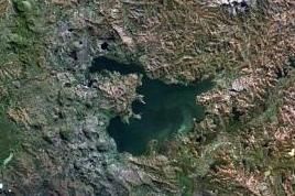
English: The Itasy volcanic field in central Madagascar.
  • It lies west of Lake Itasy (lower-center) and consists of a N-S-trending chain of scoria cones, lava domes, and maars. Several small dark-colored lake-filled maars can be seen in the NASA Landsat image (with north to the top), one of which lies just above the NW arm of Lake Itasy.
  • Early eruptions producing trachytic lava domes and basanitic lava flows were followed by the effusion of trachytic lava flows and recent vulcanian eruptions. Mild seismicity and hot spring activity continue at Itasy.
Date Unknown date
Source http://www.volcano.si.edu/world/volcano.cfm?vnum=0303-014&volpage=photos&photo=114074
Author NASA Landsat7 image (worldwind.arc.nasa.gov)
Other versions
image extraction process
This file has been extracted from another file
: Itasy Volcanic Field.jpg
original file

Licensing

Public domain
This image is in the public domain because it is a screenshot from NASA’s globe software World Wind using a public domain layer, such as Blue Marble, MODIS, Landsat, SRTM, USGS or GLOBE.

العربيَّة | English | فارسی | français | עברית | македонски | മലയാളം | Nederlands | русский | 中文(中国大陆)‎ | +/−

Captions

Add a one-line explanation of what this file represents

Items portrayed in this file

depicts

image/jpeg

File history

Click on a date/time to view the file as it appeared at that time.

Date/TimeThumbnailDimensionsUserComment
current09:47, 1 February 2022Thumbnail for version as of 09:47, 1 February 2022268 × 178 (16 KB)ProeksadFile:Itasy Volcanic Field.jpg cropped 58 % horizontally, 58 % vertically using CropTool with precise mode.

The following 2 pages use this file:

Global file usage

The following other wikis use this file: