Jump to content

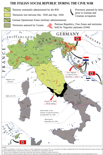
File:Italian-social-republic-and-civil-war.svg

Page contents not supported in other languages.
This is a file from the Wikimedia Commons
From Wikipedia, the free encyclopedia

Original file (SVG file, nominally 1,000 × 1,500 pixels, file size: 850 KB)

Summary

Description
English: Map of Italy during the Civil War, focusing on the Italian Social Republic
Italiano: Carta dell'Italia durante la Guerra Civile con particolare attenzione alla Repubblica Sociale Italiana
Date
Source

Own work - Bibliography: Atlante storico della Resistenza italiana by L. Baldissara, Bruno Mondadori, 2000; Storia della Guerra Civile in Italia 1943-1945 by Giorgio Pisanò, FPE, 1965-'67; Breve storia della Resistenza Italiana, FIVL, Edizioni Civitas, 1990. About OZAK: Salò-Berlino, l'alleanza difficile by Nicola Cospito, Hans W. Neulen, Mursia and this map; about Rome "open city" occupied by Germans and not capital of RSI, Renzo De Felice, Mussolini, l'Alleato. La guerra civile, Einaudi, p. 373. About German and Allies positions in Southern Italy at September 18, 1943: http://www.westpoint.edu/, Harper Collins Atlas of the Second World War, Storia della Seconda guerra mondiale, vol. 4, Rizzoli-Purnell. About the territories held by Yugoslav partisans in Dalmazia and in the Province of Ljubljana see http://upload.wikimedia.org/wikipedia/commons/f/f8/Oslobo%C4%91ena_teritorija_septembra_1944.jpg . About the British-Yugoslav occupation of Lissa (Vis), see: "Chronology and Index of the Second World War, 1938-1945" (The Royal Institute of International Affairs) and "Tito, Mihailović, and the Allies, 1941-1945" (Walter R. Roberts). About the names of cities see http://images.nationmaster.com/images/motw/historical/italy_1921.jpg

Original map realized for the congress “Agricoltura e vita quotidiana nella RSI” (Salò, Italy, October 2004) - new version updated and remedied on Storia in Rete n. 49-50 (released in CC 3.0 SA by).
Author Emanuele Mastrangelo
Other versions

[edit]

Licensing

I, the copyright holder of this work, hereby publish it under the following license:
w:en:Creative Commons
attribution share alike
This file is licensed under the Creative Commons Attribution-Share Alike 4.0 International license.
You are free:
  • to share – to copy, distribute and transmit the work
  • to remix – to adapt the work
Under the following conditions:
  • attribution – You must give appropriate credit, provide a link to the license, and indicate if changes were made. You may do so in any reasonable manner, but not in any way that suggests the licensor endorses you or your use.
  • share alike – If you remix, transform, or build upon the material, you must distribute your contributions under the same or compatible license as the original.
Nazi symbol Legal disclaimer
This image shows (or resembles) a symbol that was used by the National Socialist (NSDAP/Nazi) government of Germany or an organization closely associated to it, or another party which has been banned by the Federal Constitutional Court of Germany.

The use of insignia of organizations that have been banned in Germany (like the Nazi swastika or the arrow cross) may also be illegal in Austria, Brazil, the Czech Republic, France, Hungary, Israel, Poland, Russia, Ukraine and other countries, depending on context. In Germany, the applicable law is paragraph 86a of the criminal code (StGB), in Poland – Art. 256 of the criminal code (Dz.U. 1997 nr 88 poz. 553).

Captions

Add a one-line explanation of what this file represents

Items portrayed in this file

depicts

15 October 2014

image/svg+xml

File history

Click on a date/time to view the file as it appeared at that time.

(newest | oldest) View (newer 10 | ) (10 | 20 | 50 | 100 | 250 | 500)
Date/TimeThumbnailDimensionsUserComment
current09:48, 8 December 2021Thumbnail for version as of 09:48, 8 December 20211,000 × 1,500 (850 KB)Andrei StroeFile uploaded using svgtranslate tool (https://svgtranslate.toolforge.org/). Added translation for ro.
16:18, 1 April 2015Thumbnail for version as of 16:18, 1 April 20151,000 × 1,500 (832 KB)NikNaksReverted to version as of 16:30, 31 March 2015
17:27, 31 March 2015Thumbnail for version as of 17:27, 31 March 20151,000 × 1,500 (802 KB)NikNaksreplace fortifications with text Vs
16:30, 31 March 2015Thumbnail for version as of 16:30, 31 March 20151,000 × 1,500 (832 KB)P. S. Burton
16:28, 31 March 2015Thumbnail for version as of 16:28, 31 March 20151,000 × 1,500 (832 KB)P. S. Burton
16:26, 31 March 2015Thumbnail for version as of 16:26, 31 March 20151,000 × 1,500 (832 KB)P. S. Burtontrying again
16:22, 31 March 2015Thumbnail for version as of 16:22, 31 March 20151,000 × 1,500 (832 KB)P. S. Burtontext corrections
15:55, 31 March 2015Thumbnail for version as of 15:55, 31 March 20151,000 × 1,500 (832 KB)NikNakssimplified circle pattern
15:30, 31 March 2015Thumbnail for version as of 15:30, 31 March 20151,000 × 1,500 (840 KB)NikNakserror in striped area
21:24, 30 March 2015Thumbnail for version as of 21:24, 30 March 20151,000 × 1,500 (882 KB)NikNakssize of "FRANCE" fixed
(newest | oldest) View (newer 10 | ) (10 | 20 | 50 | 100 | 250 | 500)

Global file usage

The following other wikis use this file:

Metadata