File:Iron ore Pilbara.jpg
Appearance

Size of this preview: 800 × 586 pixels. Other resolutions: 320 × 234 pixels | 640 × 469 pixels | 1,024 × 750 pixels | 1,280 × 938 pixels | 2,048 × 1,500 pixels.
Original file (2,048 × 1,500 pixels, file size: 268 KB, MIME type: image/jpeg)
File history
Click on a date/time to view the file as it appeared at that time.
| Date/Time | Thumbnail | Dimensions | User | Comment | |
|---|---|---|---|---|---|
| current | 07:59, 7 December 2010 |  | 2,048 × 1,500 (268 KB) | Calistemon | Colored in ocean. |
| 07:32, 7 December 2010 |  | 2,048 × 1,500 (266 KB) | Calistemon | Town names in bold and black. | |
| 07:14, 7 December 2010 |  | 2,048 × 1,500 (264 KB) | Calistemon | Coloring in of land mass, as done by User:Gnangarra. | |
| 02:03, 7 December 2010 |  | 2,048 × 1,500 (263 KB) | Calistemon | Fixed spelling mistake. | |
| 01:54, 7 December 2010 |  | 2,048 × 1,500 (266 KB) | Calistemon | Add barrow Island, Gorgon, the Sino project and Western Turner. | |
| 01:34, 7 December 2010 |  | 2,048 × 1,500 (257 KB) | Calistemon | Increased size of writing. | |
| 02:18, 5 December 2010 |  | 2,048 × 1,500 (238 KB) | Calistemon | Clean up map, add some more locations. | |
| 15:05, 4 December 2010 |  | 2,048 × 1,500 (235 KB) | Calistemon | Added missing Mount Tom Price mine, removed section of road thats not a major road. | |
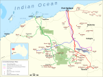
| 14:40, 4 December 2010 |  | 2,048 × 1,500 (234 KB) | Calistemon | {{Information |Description={{en|1=Map of the iron ore mines in the Pilbara region of Western Australia.}} |Source={{own}} |Author=Calistemon |Date=2010-12-04 |Permission= |other_versions= }} |
File usage
The following page uses this file:


