Jump to content

File:Indo-European branches map.png

Page contents not supported in other languages.
This is a file from the Wikimedia Commons
From Wikipedia, the free encyclopedia

Original file (2,934 × 2,938 pixels, file size: 1.91 MB, MIME type: image/png)

File:Indo-European branches map.svg is a vector version of this file. It should be used in place of this PNG file when not inferior.

File:Indo-European branches map.png → File:Indo-European branches map.svg

For more information, see Help:SVG.

In other languages
Alemannisch  العربية  беларуская (тарашкевіца)  български  বাংলা  català  нохчийн  čeština  dansk  Deutsch  Ελληνικά  English  British English  Esperanto  español  eesti  euskara  فارسی  suomi  français  Frysk  galego  Alemannisch  עברית  hrvatski  magyar  հայերեն  Bahasa Indonesia  Ido  italiano  日本語  ქართული  한국어  lietuvių  македонски  മലയാളം  Bahasa Melayu  norsk bokmål  Plattdüütsch  Nederlands  norsk nynorsk  norsk  occitan  polski  prūsiskan  português  português do Brasil  română  русский  sicilianu  Scots  slovenčina  slovenščina  српски / srpski  svenska  தமிழ்  ไทย  Türkçe  татарча / tatarça  українська  vèneto  Tiếng Việt  中文  中文(中国大陆)  中文(简体)  中文(繁體)  中文(马来西亚)  中文(新加坡)  中文(臺灣)  中文(臺灣)  +/−
New SVG image

Any autoconfirmed user can overwrite this file from the same source. Please ensure that overwrites comply with the guideline.

Summary

Description
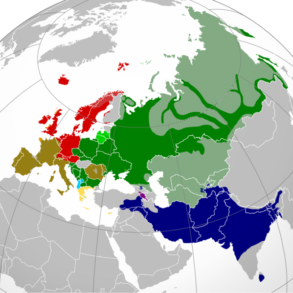
English: A map showing the approximate present-day distribution of the Indo-European branches within their homelands of Europe and Asia. The following legend is given in the chronological order of the earliest surviving written attestations of each branch:
 
Italic (includes Romance) [9]
 
Non-Indo-European languages
Dotted/striped areas indicate where multilingualism is common (more visible upon full enlargement of the map).
Date
Source

For the names of the branches, see citations in legend (based on "Indo-European Languages". The College of Liberal Arts. UT Austin. 2008.) and "Indo-European languages" from Britannica.com.

The distribution is essentially and approximately based on the map "Indo-European languages – Approximate locations of Indo-European languages in contemporary Eurasia" from Britannica.com, although with the following minor modifications:

The two articles "Balto-Slavic languages" and "Indo-Iranian languages" from Britannica.com stress the lack of scholarly consensus on these branches. That is, for the former, whether Baltic and Slavic developed from a common ancestral language, or that the similarities are the result of parallel development and of mutual influence during a long period of contact. To cater for both scholarly viewpoints, this map shows Baltic and Slavic with two distinct shades of green under "Balto-Slavic". For the latter, the dispute is whether the Indo-Iranian languages include just the Iranian and Indo-Aryan (or, Indic) language groups, or Nūristānī and Bangani too. To prevent disagreement (and also because this map only represents the primary branches of Indo-European), all of Indo-Iranian is represented with one shade.

The article "Romance languages" from Britannica.com states that the Romance languages form "a subgroup of the Italic branch of the Indo-European language family".

It should be noted that this map is only approximative and simplified, and glosses over some multilingual areas (particularly in eastern Russia, which is difficult to represent accurately). For some areas, more regional maps have been used as sources for greater accuracy, namely "Languages of Switzerland" from Ethnologue.com, "Russia ethnic plurality" from Freelang.net, "Major ethnic groups in Central Asia" from Globalsecurity.org, and "South Asian Language Families" from "Language families and branches, languages and dialects in A Historical Atlas of South Asia". Oxford University Press. New York 1992.
Author Hayden120
Permission
(Reusing this file)
I, the copyright holder of this work, hereby publish it under the following licenses:
w:en:Creative Commons
attribution share alike
This file is licensed under the Creative Commons Attribution-Share Alike 3.0 Unported, 2.5 Generic, 2.0 Generic and 1.0 Generic license.
You are free:
  • to share – to copy, distribute and transmit the work
  • to remix – to adapt the work
Under the following conditions:
  • attribution – You must give appropriate credit, provide a link to the license, and indicate if changes were made. You may do so in any reasonable manner, but not in any way that suggests the licensor endorses you or your use.
  • share alike – If you remix, transform, or build upon the material, you must distribute your contributions under the same or compatible license as the original.
GNU head Permission is granted to copy, distribute and/or modify this document under the terms of the GNU Free Documentation License, Version 1.2 or any later version published by the Free Software Foundation; with no Invariant Sections, no Front-Cover Texts, and no Back-Cover Texts. A copy of the license is included in the section entitled GNU Free Documentation License.
You may select the license of your choice.

Captions

A map showing the approximate present-day distribution of the Indo-European branches within their homelands of Europe and Asia.

Items portrayed in this file

depicts

16 January 2012

image/png

File history

Click on a date/time to view the file as it appeared at that time.

(newest | oldest) View (newer 10 | ) (10 | 20 | 50 | 100 | 250 | 500)
Date/TimeThumbnailDimensionsUserComment
current09:28, 7 June 2024Thumbnail for version as of 09:28, 7 June 20242,934 × 2,938 (1.91 MB)Goldenupdate Karabakh
03:43, 26 September 2022Thumbnail for version as of 03:43, 26 September 20222,934 × 2,938 (2.16 MB)Alexikouaminor fixes
15:58, 30 March 2022Thumbnail for version as of 15:58, 30 March 20222,934 × 2,938 (1.74 MB)Whoop whoop pull upWhoops, wrong file!
15:37, 30 March 2022Thumbnail for version as of 15:37, 30 March 20222,048 × 2,048 (980 KB)Whoop whoop pull upMisc fixes (Russian minority in Svalbard & Israel, Slovenian in SE Carinthia, Greek in N Epirus, Aromanians/Megleno-Romanians, Swedish essentially extinct in Estonia, etc.
09:37, 22 December 2021Thumbnail for version as of 09:37, 22 December 20212,934 × 2,938 (1.74 MB)Ahmet Q.Reverted to version as of 19:55, 23 August 2021 (UTC)seek consensus for your changes
20:40, 25 November 2021Thumbnail for version as of 20:40, 25 November 20212,934 × 2,938 (2.16 MB)Alexikouarv elimination of Greek minority in Albania
19:55, 23 August 2021Thumbnail for version as of 19:55, 23 August 20212,934 × 2,938 (1.74 MB)Ahmet Q.Rv false edit summary. Overrepresentation of Greeks in Turkey, Albania and Ukraine. Unexplained removal of Romanian in Serbia. Overall deterioration of the original file. Seek consensus for your changes.
16:16, 7 August 2021Thumbnail for version as of 16:16, 7 August 20212,934 × 2,938 (2.16 MB)Demetrios1993Addition of Arbereshe linguistic minority in Sicily. Addition of Serbian, Bosnian, and Gorani linguistic minorities in Kosovo. Addition of Greek linguistic minorities in Italy, Albania, Turkey, and Ukraine. Including some other minor corrections.
17:00, 19 November 2020Thumbnail for version as of 17:00, 19 November 20202,934 × 2,938 (1.74 MB)Goldenupdate Armenian
18:42, 31 March 2018Thumbnail for version as of 18:42, 31 March 20181,479 × 1,479 (574 KB)MaphobbyistRemoved area that exactly corresponds to the non-Indo European Lezgi linguistic area.
(newest | oldest) View (newer 10 | ) (10 | 20 | 50 | 100 | 250 | 500)

Global file usage

The following other wikis use this file:

View more global usage of this file.

Metadata