Jump to content

File:Ile Mysterieuse 03.jpg

Page contents not supported in other languages.
This is a file from the Wikimedia Commons
From Wikipedia, the free encyclopedia

Original file (1,443 × 2,208 pixels, file size: 751 KB, MIME type: image/jpeg)

Summary

Description
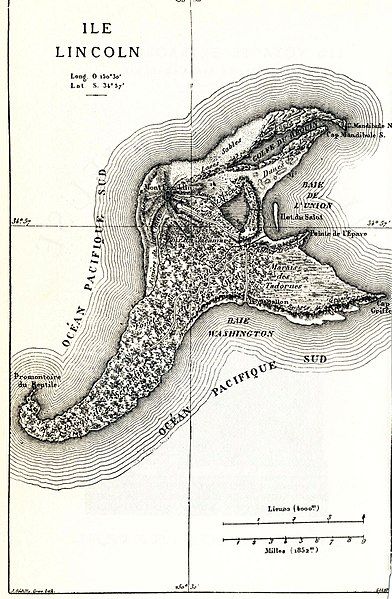
English: Map of the fictional Lincoln Island (The Mysterious Island).
Date
Source
English: This image was originally featured in the Hetzel edition of Mysterious Island, and has also been featured in more recent editions (this particular instance was scanned from a recent edition).
Author
Jules Verne  (1828–1905)  wikidata:Q33977 s:en:Author:Jules Gabriel Verne q:en:Jules Verne
 
Jules Verne
Alternative names
Birth name: Jules Gabriel Verne; Julius Verne
Description French writer
Date of birth/death 8 February 1828 Edit this at Wikidata 24 March 1905 Edit this at Wikidata
Location of birth/death Nantes Edit this at Wikidata Amiens Edit this at Wikidata
Work period 1850 Edit this at Wikidata–1905 Edit this at Wikidata
Authority file
creator QS:P170,Q33977
Jules Férat  (1829–1906)  wikidata:Q3509579 s:en:Author:Jules-Descartes Férat
 
Jules Férat
Alternative names
Birth name: Jules Descartes Férat; Jules-Descartes Férat; Jules Ferat; Jules-Descartes Ferat; Jules Descartes Ferat; J. Férat
Description French illustrator, painter, engraver and printmaker
Date of birth/death 28 November 1829 Edit this at Wikidata 6 June 1906 Edit this at Wikidata
Location of birth/death Ham Edit this at Wikidata Paris Edit this at Wikidata
Authority file
creator QS:P170,Q3509579
Charles Barbant  (1844–1921)  wikidata:Q15407115 s:fr:Auteur:Charles Barbant
 
Charles Barbant
Alternative names
Ch. Barbant
Description French illustrator and printmaker
Date of birth/death 15 July 1844 Edit this at Wikidata 10 May 1921 Edit this at Wikidata
Location of birth/death Paris Edit this at Wikidata 11th arrondissement of Paris Edit this at Wikidata
Work period 1874 Edit this at Wikidata
Work location
Authority file
creator QS:P170,Q15407115
Permission
(Reusing this file)
This is a French work. French law applies. France does not use the notion of "copyright", but a "Droit d'auteur" system. They are now the public domain, since their Droit d'auteur is expired.
Other versions
Camera location34° 56′ 00″ S, 150° 30′ 00″ W Kartographer map based on OpenStreetMap.View this and other nearby images on: OpenStreetMapinfo

Licensing

Public domain

This work is in the public domain in its country of origin and other countries and areas where the copyright term is the author's life plus 100 years or fewer.


This work is in the public domain in the United States because it was published (or registered with the U.S. Copyright Office) before January 1, 1929.

This file has been identified as being free of known restrictions under copyright law, including all related and neighboring rights.

Captions

Add a one-line explanation of what this file represents

Items portrayed in this file

depicts

34°55'59.999"S, 150°30'0.000"W

File history

Click on a date/time to view the file as it appeared at that time.

Date/TimeThumbnailDimensionsUserComment
current13:57, 10 August 2017Thumbnail for version as of 13:57, 10 August 20171,443 × 2,208 (751 KB)The RedBurnLevels corrected with XnView
21:41, 25 February 2005Thumbnail for version as of 21:41, 25 February 20051,443 × 2,208 (664 KB)Rama{{PD}}

Global file usage

The following other wikis use this file:

Metadata