Jump to content

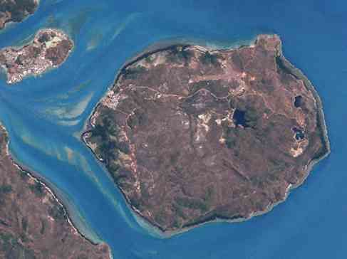
File:Horn Island, Torres Strait (Landsat).jpg

Page contents not supported in other languages.
This is a file from the Wikimedia Commons
From Wikipedia, the free encyclopedia

Horn_Island,_Torres_Strait_(Landsat).jpg (487 × 364 pixels, file size: 13 KB, MIME type: image/jpeg)

Summary

Description
English: Horn Island, Inner Group of Torres Strait Islands, Queensland, Australia. Northwest shows Thursday Island, southwest a piece from Prince-of-Wales-Island.
Date
Source http://oceancolor.gsfc.nasa.gov/cgi/landsat_extract.pl?path=99&row=67&x=1733&y=1804&n=0&t=321
Author NASA

Merged two close-by tiles from NASA-Landsat (30-meter resolution) mosaics. Other source tile is: http://oceancolor.gsfc.nasa.gov/cgi/landsat_extract.pl?path=99&row=67&x=1733&y=2034&n=0&t=321

Licensing

Public domain This file is in the public domain in the United States because it was solely created by NASA. NASA copyright policy states that "NASA material is not protected by copyright unless noted". (See Template:PD-USGov, NASA copyright policy page or JPL Image Use Policy.)
Warnings:

Captions

Add a one-line explanation of what this file represents

Items portrayed in this file

depicts

11 November 2011

File history

Click on a date/time to view the file as it appeared at that time.

Date/TimeThumbnailDimensionsUserComment
current11:09, 11 November 2011Thumbnail for version as of 11:09, 11 November 2011487 × 364 (13 KB)Wurfzoll

The following page uses this file:

Global file usage

The following other wikis use this file: