Jump to content

File:Grenoble Tassin 1638.jpg

Page contents not supported in other languages.
This is a file from the Wikimedia Commons
From Wikipedia, the free encyclopedia

Original file (1,812 × 1,232 pixels, file size: 1.12 MB, MIME type: image/jpeg)

Summary

Description
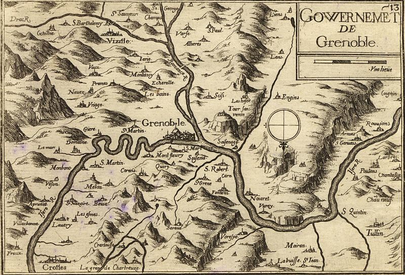
Français : Carte géographique ancienne de la région de Grenoble (Isère - Dauphiné - France) par Tassin aux alentours de 1638). Il est intéressant de noter l'orientation inhabituelle Sud - Nord de cette carte ainsi que la toponymie très différente de celle d'aujourd'hui. Ainsi par exemple, Meylan était alors orthographié Mélan. A noter l'inversion entre Drac et Romanche
English: Old map of Grenoble area (Dauphiné - Isère - France) by Tassin circa 1638. Of interest is the unconventional South-North orientation of this map as well as the different toponomy. For example, Meylan is shown as "Mélan" on the map. Note that the rivers Drac and Romanche are inverted
Date
Source
Author Tassin (reproduit par histoirepostale.net)
Camera location45° 11′ 39.39″ N, 5° 43′ 53.88″ E Kartographer map based on OpenStreetMap.View this and other nearby images on: OpenStreetMapinfo

Licensing

This is a faithful photographic reproduction of a two-dimensional, public domain work of art. The work of art itself is in the public domain for the following reason:
Public domain

This work is in the public domain in its country of origin and other countries and areas where the copyright term is the author's life plus 100 years or fewer.


You must also include a United States public domain tag to indicate why this work is in the public domain in the United States.
This file has been identified as being free of known restrictions under copyright law, including all related and neighboring rights.
The official position taken by the Wikimedia Foundation is that "faithful reproductions of two-dimensional public domain works of art are public domain".
This photographic reproduction is therefore also considered to be in the public domain in the United States. In other jurisdictions, re-use of this content may be restricted; see Reuse of PD-Art photographs for details.

Captions

Add a one-line explanation of what this file represents

Items portrayed in this file

depicts

45°11'39.394"N, 5°43'53.882"E

File history

Click on a date/time to view the file as it appeared at that time.

Date/TimeThumbnailDimensionsUserComment
current07:43, 21 April 2008Thumbnail for version as of 07:43, 21 April 20081,812 × 1,232 (1.12 MB)Dlebouc{{Information |Description= |Source= |Date= |Author= |Permission= |other_versions= }}
08:41, 3 February 2008Thumbnail for version as of 08:41, 3 February 20081,812 × 1,232 (1.12 MB)Dlebouc== Description == {{Information |Description= {{fr|Carte géographique ancienne de la Tunisie par Vuillemin,Thuilier, Lacoste et Lorsignol (Paris 1902).}} {{en|Map of Tunisia by Vuillemin,Thuilier, Lacoste et Lorsignol (Paris 1902.}} |Source= {{fr|[http:/

The following 2 pages use this file:

Global file usage

The following other wikis use this file:

Metadata