Jump to content

File:Greenland snow machine tracks OLLI.jpg

Page contents not supported in other languages.
This is a file from the Wikimedia Commons
From Wikipedia, the free encyclopedia

Greenland_snow_machine_tracks_OLLI.jpg (720 × 600 pixels, file size: 578 KB, MIME type: image/jpeg)

Summary

Description

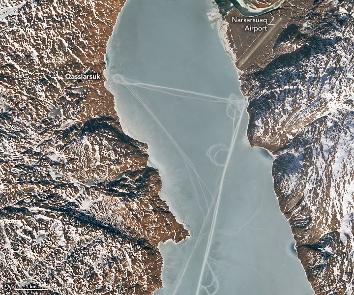
On March 13, 2023, the Operational Land Imager-2 (OLI-2) on Landsat 9 acquired these natural-color images of Tunulliarfik Fjord. The images have been pan-sharpened to bring out more detail. At the time, the fjord’s waters were capped with a layer of sea ice. Atop the ice there are several long, straight lines connecting the towns of Narsarsuaq and Qassiarsuk, and running the length of the fjord. Though cracks and ridges can form naturally in the ice, there are indications that people were likely involved with producing some of the tracks pictured here. Nathan Kurtz and several other scientists in the Cryospheric Sciences Laboratory at NASA’s Goddard Space Flight Center reviewed the images. Their consensus was that many of the tracks, especially those that include loops, were likely produced by vehicles, such as snowmobiles. “It seems likely that residents from the town or nearby were out on the ice, possibly hunting or traveling,“ Kurtz said. Traversing the frozen fjord with a vehicle would make sense given its size. The track that connects the small towns of Qassiarsuk and Narsarsuaq, visible in the first detailed image above, spans about 4 kilometers (2.5 miles). The track that runs the length of the fjord is at least 20 kilometers (12 miles) long.

Mixed amid the geometric shapes, some of the “lines” show more variation. They are particularly notable in the second detailed image above. “These look like natural ice deformation features, most likely cracks or ridging due to tidal motion,” Kurtz said.
Date
Source https://earthobservatory.nasa.gov/images/151243/curious-tracks-criss-cross-an-icy-fjord
Author NASA OLLI Earth Observatory
Permission
(Reusing this file)
Public domain This file is in the public domain in the United States because it was solely created by NASA. NASA copyright policy states that "NASA material is not protected by copyright unless noted". (See Template:PD-USGov, NASA copyright policy page or JPL Image Use Policy.)
Warnings:

Captions

Add a one-line explanation of what this file represents

Items portrayed in this file

depicts

image/jpeg

13 March 2023

591,708 byte

600 pixel

720 pixel

48bf7fb8e245422242e8c6ffc2ad0ee69cabc88c

File history

Click on a date/time to view the file as it appeared at that time.

Date/TimeThumbnailDimensionsUserComment
current18:22, 26 April 2023Thumbnail for version as of 18:22, 26 April 2023720 × 600 (578 KB)Tillman{{Information |Description=On March 13, 2023, the Operational Land Imager-2 (OLI-2) on Landsat 9 acquired these natural-color images of Tunulliarfik Fjord. The images have been pan-sharpened to bring out more detail. At the time, the fjord’s waters were capped with a layer of sea ice. Atop the ice there are several long, straight lines connecting the towns of Narsarsuaq and Qassiarsuk, and running the length of the fjord. Though cracks and ridges can form naturally in the ice, there are indic...

The following page uses this file: