File:Great Moravia not cropped, eng labels.svg
Page contents not supported in other languages.
Tools
Actions
General
In other projects
Appearance

Size of this PNG preview of this SVG file: 463 × 599 pixels. Other resolutions: 185 × 240 pixels | 371 × 480 pixels | 593 × 768 pixels | 791 × 1,024 pixels | 1,582 × 2,048 pixels | 2,550 × 3,300 pixels.
Original file (SVG file, nominally 2,550 × 3,300 pixels, file size: 643 KB)
| This is a file from the Wikimedia Commons. Information from its description page there is shown below. Commons is a freely licensed media file repository. You can help. |
Summary
| DescriptionGreat Moravia not cropped, eng labels.svg | Historical map of Great Moravia |
| Date | 2.7.2007 |
| Source | Own work; based on Image:Europe-slk.svg (which is based on CIA World Factbook (image), geodesy.gov.sk, Wikipedia (Slovak labels)) |
| Author | Bronto, ~~Helix84 |
| Other versions | see below |
This is the vector source for following exported images (cropped): Image:Great Moravia-eng.png
All related images (exported from same source):
-
Vector source, no labels
-
Vector source, German labels
-
Vector source, English labels
-
Vector source, French labels
-
Vector source, Slovak labels
-
Vector source, Polish labels
-
Cropped export, no labels
-
Cropped export, German labels
-
Cropped export, English labels
-
Cropped export, French labels
-
Cropped export, Polish labels
-
Cropped export, Slovak labels
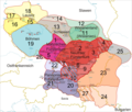
Slovenčina: Legenda:
1: od 833 do 907: Moravské kniežatstvo
2: od 833 do 907: Nitrianske kniežatstvo
3: spolu s  2 alebo spolu s 4
4: od 833 alebo od vlády Rastislava do (?)896: Nitrianske kniežatstvo
5: spolu s 1 alebo od roku 853/54 do (?)907: Moravské kniežatstvo
6: od roku 858 do (?)894: Nitrianske kniežatstvo
7: spolu s 2 alebo spolu s 22:
8: spolu s 6 alebo spolu s 20
9: od vlády Rastislava (846-870) alebo Svätopluka I. (871-894) do 896: Nitrianske kniežatstvo
10: spolu s 8 alebo spolu s 20
11: od 874 do (?) 907: Visliansko
12: pravdepodobne spolu s 11
13: od 880 do ?: Sliezsko (podľa niektorých názorov nebolo pripojené)
14: pravdepodobne spolu s 14
15: od 890 do 897: Lužica
16: veľmi pravdepodobne spolu s 15
17: veľmi pravdepodobne spolu s 15
18: pravdepodobne spolu s 15-17
19: od 888/890 do 894: Čechy
20: od 883/884 do 894: Panónske kniežatstvo
21: veľmi pravdepodobne spolu s 20
22: spolu s 20 (a 21): možno Panónske kniežatstvo
23: od 881/882 do 896: Zátisie
24: pravdepodobne spolu s 23
25: od vlády Svätopluka (871-894) do (?) 896
26: od vlády Svätopluka (871-894) do ?
27: spolu s 23 alebo spolu s 24
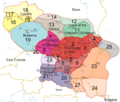
English:
Legend:
yellow lines: current borders
blue lines: rivers
red dots: main castles/settlements
1: from 833 to 907: Principality of Moravia
2: from 833 to 907: Principality of Nitra
3: along with 2 or along with 4
4: from 833 or from the reign of Rastislav to (?)896: Principality of Nitra
5: along with 1 or from 853/54 to (?)907: Princiaplity of Moravia
6: from 858 to (?)894: Principality of Nitra
7: along with 2 or along with 22
8: along with 6 or along with 20
9: from the reign of Rastislav (846-870) or of Svätopluk I (871-894) to 896: Principality of Nitra
10: along with 8 or along with 20
11: from 874 to (?) 907: Wislania
12: probably along with 11
13: from 880 to ?: Silesia (Silesia was not annexed according to some authors)
14: probably along with 14
15: from 890 to 897: Lusatia
16: with a high probability along with 15
17: with a high probability along with 15
18: probably along with 15-17
19: from 888/890 to 894: Bohemia
20: from 883/884 to 894: Pannonian Principality (Balaton Principality)
21: with a high probability along with 20
22: along with 20 (and 21): maybe part of the Pannonian Principality (Balaton Principality)
23: from 881/882 to 896: "Transtheissia"
24: probably along with 23
25: from the reign of Svätopluk (871-894) to (?) 896
26: from the reign of Svätopluk (871-894) to ?
27: along with 23 or along with 24
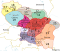
Deutsch:
Legende:
gelbe Linien: aktuelle Grenzen
blaue Linien: Flüsse
rote Punkte: die wichtigsten Burgwälle/Siedlungen
1: von 833 bis 907: Mährisches Fürstentum
2: von 833 bis 907: Neutraer Fürstentum
3: zusammen mit 2 oder zusammen mit 4
4: von 833 oder von der Regierungszeit Rastislavs bis (?)896: Neutraer Fürstentum
5: zusammen mit 1 oder von 853/54 bis (?)907: Mährisches Fürstentum
6: von 858 bis (?)894: Neutraer Fürstentum
7: zusammen mit 2 oder zusammen mit 22
8: zusammen mit 6 oder zusammen mit 20
9: von der Regierungszeit Rastislavs (846-870) oder Sventopluks I. (871-894) bis 896: Neutraer Fürstentum
10: zusammen mit 8 oder zusammen mit 20
11: von 874 bis (?) 907: Wislanenland
12: wahrscheinlich zusammen mit 11
13: von 880 bis ?: Schlesien (Schlesien wurde einigen Autoren zufolge nicht angeschlossen)
14: wahrscheinlich zusammen mit 14
15: von 890 bis 897: Lausitz
16: höchstwahrscheinlich zusammen mit 15
17: höchstwahrscheinlich zusammen mit 15
18: wahrscheinlich zusammen mit 15-17
19: von 888/890 bis 894: Bohemia
20: von 883/884 bis 894: Plattensee-Fürstentum
21: höchstwahrscheinlich zusammen mit 20
22: zusammen mit 20 (und 21): vielleicht Teil des Plattensee-Fürstentums
23: von 881/882 bis 896: "Transtheissia"
24: wahrscheinlich zusammen mit 23
25: von der Regierungszeit Sventopluks (871-894) bis (?) 896
26: von der Regierungszeit Sventopluks (871-894) bis ?
27: zusammen mit 23 oder zusammen mit 24
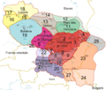
Français :
Légende:

Lignes jaunes: frontières actuelles
Lignes bleues: rivières
Points rouges: châteaux forts principaux/colonies principales
1: de 833 à 907: Principauté de Moravie
2: de 833 à 907: Principauté de Nitra
3: en même temps que 2 ou en même temps que 4
4: de 833 ou du règne de Rastislav à (?)896: Principauté de Nitra
5: en même temps que 1 ou de 853/54 à (?)907: Principauté de Moravie
6: de 858 à (?)894: Principauté de Nitra
7: en même temps que 2 ou en même temps que 22
8: en même temps que 6 ou en même temps que 20
9: du règne de Rastislav (846-870) ou de Svätopluk I (871-894) to 896: Principauté de Nitra
10: en même temps que 8 ou en même temps que 20
11: de 874 à (?) 907: Pays des Vistuliens
12: probablement en même temps que 11
13: de 880 à ?: Silésie (la Silésie n‘a pas été annexée d’après quelques auteurs)
14: probablement en même temps que 14
15: de 890 à 897: Lusatie
16: très probablement en même temps que 15
17: très probablement en même temps que 15
18: probablement en même temps que 15-17
19: de 888/890 à 894: Bohême
20: de 883/884 à 894: Principauté de Pannonie
21: très probablement en même temps que 20
22: en même temps que 20 (and 21): peut-être une partie de la Principauté de Pannonie
23: de 881/882 à 896
24: probablement en même temps que 23
25: du règne de Svätopluk (871-894) à (?) 896
26: du règne de Svätopluk (871-894) à ?
27: en même temps que 23 ou en même temps que 24
Main sources:
Čaplovič, Dušan: Včasnostredoveké osídlenie Slovenska, 1998, Bratislava
Dvořák, Pavel: Stopy dávnej minulosti – Zrod národa, 2004, Bratislava
Frolík, Jan et al.:  Velké dějiny zemí Koruny české I., 1999, Praha
Gurňák, Daniel: Štáty v premenách storočí – Dejepisný atlas, 2006, Bratislava
Kováč, Dušan et al.: Kronika Slovenska 1., 1998, Bratislava
Marsina, Richard et al.:  Dejiny Slovenska I., 1986, Bratislava
Ratkoš, Peter: Slovensko v dobe veľkomoravskej, 1988, Košice
Segeš, Vladimír; Višváder, František: Kniha kráľov - Panovníci v dejinách Slovenska a Slovákov, 1998, Bratislava
Steinhübel, Ján: Nitrianske kniežatstvo, 2004, Bratislava
Štefanovičová, Tatiana: Osudy starých Slovanov, 1989, Bratislava
Třeštík, Dušan: Vznik Velké Moravy. Moravané, Čechové a střední Evropa v letech 781-871, 2001, Praha
Licensing
I, Helix84, the copyright holder of this work, hereby publishes it under the following licenses:

|
Permission is granted to copy, distribute and/or modify this document under the terms of the GNU Free Documentation License, Version 1.2 or any later version published by the Free Software Foundation; with no Invariant Sections, no Front-Cover Texts, and no Back-Cover Texts. A copy of the license is included in the section entitled GNU Free Documentation License.http://www.gnu.org/copyleft/fdl.htmlGFDLGNU Free Documentation Licensetruetrue |
| This file is licensed under the Creative Commons Attribution-Share Alike 3.0 Unported license. | ||
| Attribution: I, Helix84 | ||
| ||
| This licensing tag was added to this file as part of the GFDL licensing update.http://creativecommons.org/licenses/by-sa/3.0/CC BY-SA 3.0Creative Commons Attribution-Share Alike 3.0truetrue |
This file is licensed under the Creative Commons Attribution 2.5 Generic license.
Attribution: I, Helix84
- You are free:
- to share – to copy, distribute and transmit the work
- to remix – to adapt the work
- Under the following conditions:
- attribution – You must give appropriate credit, provide a link to the license, and indicate if changes were made. You may do so in any reasonable manner, but not in any way that suggests the licensor endorses you or your use.
You may select the license of your choice.
Captions
Add a one-line explanation of what this file represents
Items portrayed in this file
depicts
File history
Click on a date/time to view the file as it appeared at that time.
| Date/Time | Thumbnail | Dimensions | User | Comment | |
|---|---|---|---|---|---|
| current | 11:49, 9 February 2010 |  | 2,550 × 3,300 (643 KB) | AnonMoos | minor code fixes |
| 21:40, 28 July 2007 | No thumbnail | (644 KB) | Helix84 | == Opis súboru == {{Information |Description=Historical map of Great Moravia |Source=self-made; based on Image:Europe-slk.svg (which is based on CIA World Factbook (image), geodesy.gov.sk, Wikipedia (Slovak labels)) |Date=2.7.200 |
File usage
No pages on the English Wikipedia use this file (pages on other projects are not listed).
Global file usage
The following other wikis use this file:
- Usage on de.wikibooks.org
- Usage on de.wikiversity.org
- Usage on lv.wikipedia.org


