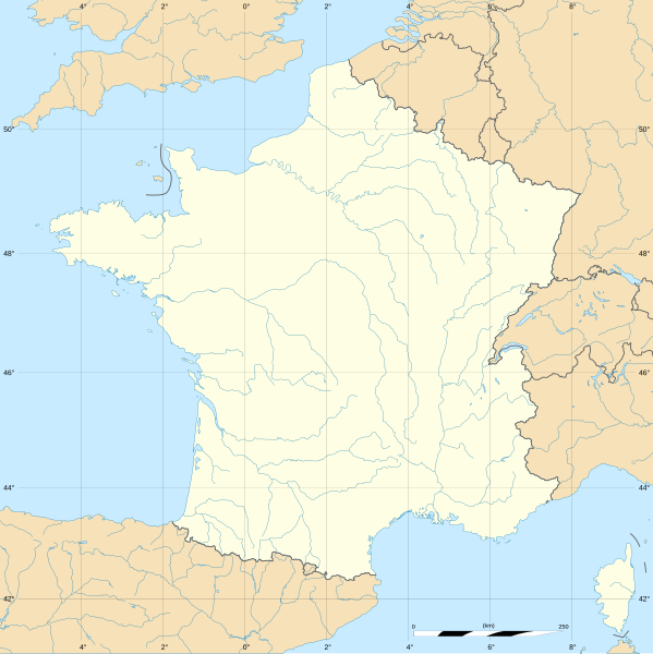
File:France blank.svg
Appearance

Size of this PNG preview of this SVG file: 599 × 599 pixels. Other resolutions: 240 × 240 pixels | 480 × 480 pixels | 768 × 768 pixels | 1,023 × 1,024 pixels | 2,047 × 2,048 pixels | 1,796 × 1,797 pixels.
Original file (SVG file, nominally 1,796 × 1,797 pixels, file size: 240 KB)
File history
Click on a date/time to view the file as it appeared at that time.
| Date/Time | Thumbnail | Dimensions | User | Comment | |
|---|---|---|---|---|---|
| current | 13:37, 19 October 2017 |  | 1,796 × 1,797 (240 KB) | Sting | No borders over the Lake of Constance |
| 11:38, 2 October 2012 |  | 1,796 × 1,797 (232 KB) | Palosirkka | Scrubbed with http://codedread.com/scour/ | |
| 13:50, 7 November 2008 |  | 1,796 × 1,797 (559 KB) | Sting | + boundary for the Channel Islands ; - canals | |
| 02:46, 25 September 2008 |  | 1,796 × 1,797 (564 KB) | Sting | Completely new version using NGDC WDBII data and with known projection | |
| 16:34, 21 September 2006 |  | 1,796 × 1,796 (973 KB) | Sting | Colours | |
| 00:34, 20 September 2006 |  | 1,796 × 1,796 (974 KB) | Sting | {{Information |Description=SVG map of France |Source=Own work |Date=September 2006 |Author=Eric Gaba (Sting) |Permission=CC-BY-SA-2.5 |other_versions= }} ---- {{fr}} * '''Sujet :''' Carte vectorielle de la France ; * '''Auteur :''' Eric |
File usage
The following page uses this file:
Global file usage
The following other wikis use this file:
- Usage on ar.wikipedia.org
- Usage on fr.wikipedia.org
- Utilisateur:Yug/Archive2016
- Discussion modèle:Fragéoloc
- Discussion Portail:France/2005-2007
- Wikipédia:Atelier graphique/Images à améliorer/Archives/Septembre 2007
- Utilisateur:Wikisoft*/Cartes
- Utilisateur:Wikisoft*/Tests cartes 1
- Utilisateur:Wikisoft*/Modèle:Infobox Montagnes de France
- Discussion utilisateur:Wikisoft*/Modèle:Infobox Montagnes de France
- Wikipédia:Atelier graphique/Cartes/Archives/octobre 2008
- Utilisateur:Géobox/5
- Wikipédia:Atelier graphique/Cartes/Archives/juillet 2009
- Discussion utilisateur:Sting/Archive 08
- Wikipédia:Atelier graphique/Cartes/Archives/janvier 2010
- Utilisateur:Géobox/Géolocalisation/France
- Utilisateur:Wikisoft*/France
- Wikipédia:Atelier graphique/Cartes/Archives/Demandes mises en sommeil/France
- Utilisateur:Wikisoft*/Modèle:Géobox Montagnes
- Wikipédia:Opération Libre
- Usage on gan.wikipedia.org
- Usage on it.wikibooks.org
- Usage on lb.wikipedia.org


