Jump to content

File:Flight 1549-OptionsNotTaken.PNG

Page contents not supported in other languages.
This is a file from the Wikimedia Commons
From Wikipedia, the free encyclopedia

Original file (1,000 × 874 pixels, file size: 727 KB, MIME type: image/png)

This map image could be re-created using vector graphics as an SVG file. This has several advantages; see Commons:Media for cleanup for more information. If an SVG form of this image is available, please upload it and afterwards replace this template with {{vector version available|new image name}}.


It is recommended to name the SVG file “Flight 1549-OptionsNotTaken.svg”—then the template Vector version available (or Vva) does not need the new image name parameter.
Description
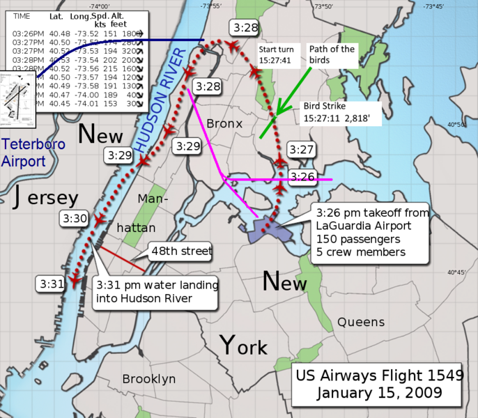
English: US Airways Flight 1549. Flightpath flown (red). Alternative trajectories to Teterboro (blue) and back toward La Guardia (purple) were simulated for the investigation. This reference states:
In his book "Fly by Wire," William Langewiesche said that the NTSB ran a simulation at Airbus facilities in Toulouse, France, to duplicate the flight operated by Sullenberger and Skiles. Wrote Langewiesche: "In the setup there were two important differences from the actual flight. First, the starting point was the location of the bird strike itself, not the location where Sullenberger came out of his turn. Second, the pilots knew the game in advance."
When the four pilots participating in the simulation responded immediately to the loss of power from the bird strike, all four were able to return safely to LaGuardia.
But in recognition that it wasn't reasonable to expect a pilot to assess the situation and react instantly, the NTSB imposed a 30-second delay before simulator pilots could turn back to LaGuardia, Langewiesche added, "and every one of them crashed."

But the real world reaction time is known: the reaction that the 1549 crew actually flew. And with the turn to the south that they actually did on the day of the incident, La Guardia was within glide distance (purple path, lower fork).
On top of this, the NTSB delay imposed on the simulator pilots neglects to state the fact that such a 30-second delay would put the jet closer to a glided approach to Teterboro Runway 24, which was reachable with or without the delay. Flight 1549 asked Air Traffic Control:

"What's over to our right? Anything in New Jersey? Maybe Teterboro?"

But this question was not initiated until near the 3:29pm marker (8 seconds prior). As can be seen on the map, by this time the aircraft was nearly abeam Teterboro Rwy 24 and could no longer land there. (See reconstructed video.)

(Derivative from map by Eigenes Werk with actual flight path overlaid by S. Bollmann.)
Date
Source US_Airways_Flight_1549.svg
Teterboro inset: Teterboro airport diagram.svg
Author ChrisnHouston
Permission
(Reusing this file)
GNU head Permission is granted to copy, distribute and/or modify this document under the terms of the GNU Free Documentation License, Version 1.2 or any later version published by the Free Software Foundation; with no Invariant Sections, no Front-Cover Texts, and no Back-Cover Texts. A copy of the license is included in the section entitled GNU Free Documentation License.

Captions

Add a one-line explanation of what this file represents

Items portrayed in this file

depicts

12 March 2010

File history

Click on a date/time to view the file as it appeared at that time.

Date/TimeThumbnailDimensionsUserComment
current11:59, 12 February 2019Thumbnail for version as of 11:59, 12 February 20191,000 × 874 (727 KB)Chrysfrom HoustonDirection of the Canadian Geese Flock was in error (reversed). Now fixed. Other tweaks made also.
01:23, 14 September 2017Thumbnail for version as of 01:23, 14 September 20171,000 × 874 (775 KB)TuntableAdded location and time of the actual bird strike.
02:53, 5 June 2016Thumbnail for version as of 02:53, 5 June 20161,000 × 874 (731 KB)ChrisnHoustonRe-adding Teterboro runway diagram, to scale.
23:25, 26 December 2015Thumbnail for version as of 23:25, 26 December 20151,000 × 874 (836 KB)MIDIReverted to version as of 19:42, 12 March 2010 (UTC) Map/sat overlay is not free-use
04:29, 18 February 2012Thumbnail for version as of 04:29, 18 February 20121,000 × 874 (831 KB)ChrisnHoustonApproximate location of, and trajectory to, Teterboro Airport added in BLUE.
19:42, 12 March 2010Thumbnail for version as of 19:42, 12 March 20101,000 × 874 (836 KB)ChrisnHouston{{Information |Description={{en|1=Optional flight paths not taken shown in purple. (Teterboro was reachable as well, but did not have this ditching alternative that an attempt back to LaGuardia had. (Derivative from map with actual flight path overlaid by

Global file usage

Metadata