File:Final 2008 electoral cartogram.png
Appearance
Final_2008_electoral_cartogram.png (552 × 348 pixels, file size: 13 KB, MIME type: image/png)
File history
Click on a date/time to view the file as it appeared at that time.
| Date/Time | Thumbnail | Dimensions | User | Comment | |
|---|---|---|---|---|---|
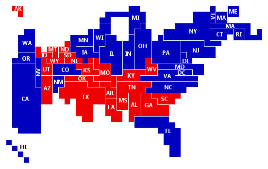
| current | 17:30, 19 December 2008 |  | 552 × 348 (13 KB) | Wes colley | Final 2008 electoral college cartogram. Blue squares represent electoral votes for Obama-Biden. Red squares represent electoral votes for McCain-Palin. Note that this cartogram is topologically correct in any two states that touch in reality touch on this |
| 17:22, 19 December 2008 |  | 552 × 348 (13 KB) | Wes colley | Final 2008 electoral college cartogram. Blue squares represent electoral votes for Obama-Biden. Red squares represent electoral votes for McCain-Palin. Note that this cartogram is topologically correct in any two states that touch in reality touch on this | |
| 17:19, 19 December 2008 |  | 552 × 348 (13 KB) | Wes colley | Final 2008 electoral college cartogram. Blue squares represent electoral votes for Obama-Biden. Red squares represent electoral votes for McCain-Palin. Note that this cartogram is topologically correct in any two states that touch in reality touch on this | |
| 17:10, 19 December 2008 |  | 552 × 348 (13 KB) | Wes colley | Final 2008 electoral college cartogram. Blue squares represent electoral votes for Obama-Biden. Red squares represent electoral votes for McCain-Palin. Note that this cartogram is topologically correct in any two states that touch in reality touch on this | |
| 16:02, 19 December 2008 |  | 552 × 348 (11 KB) | Wes colley | Final 2008 electoral college cartogram. Blue squares represent electoral votes for Obama-Biden. Red squares represent electoral votes for McCain-Palin. Note that this cartogram is topologically correct in any two states that touch in reality touch on t |
File usage
The following 2 pages use this file:
Global file usage
The following other wikis use this file:
- Usage on uk.wikipedia.org


