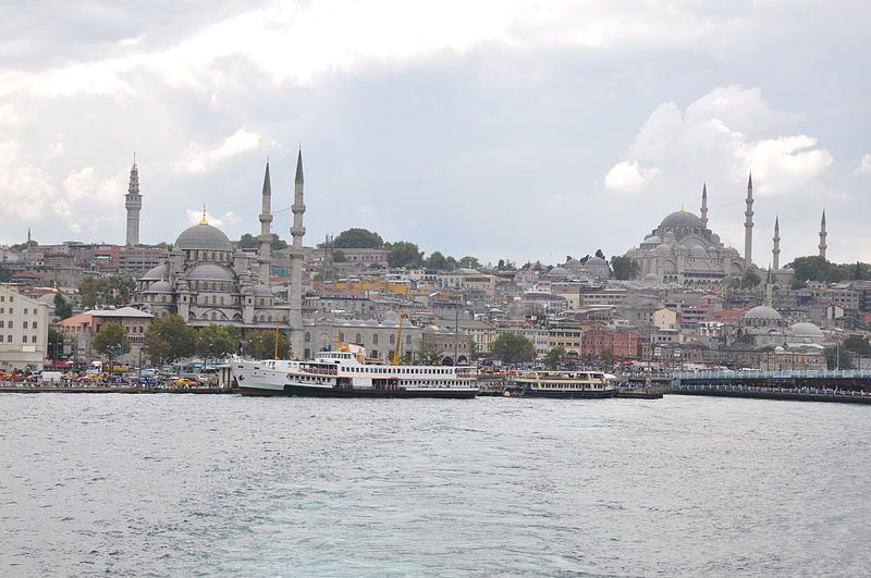
File:Eminönü (8394894494).jpg
Page contents not supported in other languages.
Tools
Actions
General
In other projects
Appearance

Size of this preview: 800 × 531 pixels. Other resolutions: 320 × 213 pixels | 640 × 425 pixels | 1,024 × 680 pixels | 1,280 × 850 pixels | 2,560 × 1,700 pixels | 4,288 × 2,848 pixels.
Original file (4,288 × 2,848 pixels, file size: 4.78 MB, MIME type: image/jpeg)
| This is a file from the Wikimedia Commons. Information from its description page there is shown below. Commons is a freely licensed media file repository. You can help. |
Summary
| DescriptionEminönü (8394894494).jpg | Eminönü is a former district of Istanbul in Turkey, now a neighbourhood of Fatih district. This is the heart of the walled city of Constantine, the focus of a history of incredible richness. Eminönü covers roughly the area on which the ancient Byzantium was built. The Galata Bridge crosses the Golden Horn into Eminönü and the mouth of the Bosphorus opens into the Marmara Sea. And up on the hill stands Topkapı Palace, the Blue Mosque (Sultanahmet Camii) and Hagia Sophia (Aya Sofya). Thus Eminönü is the main tourist destination in Istanbul. It was a part of the Fatih district until 1928, which covered the whole peninsular area (the old Stamboul) within the roman city walls - that area which was formerly the Byzantine capital Constantinople. Since the resident population of Eminönü is low today, it rejoined the Fatih district in 2009 [Wikipedia.org] |
| Date | |
| Source | Eminönü |
| Author | Jorge Láscar from Australia |
| Camera location | 41° 01′ 09.74″ N, 28° 58′ 58.45″ E | View this and other nearby images on: OpenStreetMap |
|---|
Licensing
This file is licensed under the Creative Commons Attribution 2.0 Generic license.
- You are free:
- to share – to copy, distribute and transmit the work
- to remix – to adapt the work
- Under the following conditions:
- attribution – You must give appropriate credit, provide a link to the license, and indicate if changes were made. You may do so in any reasonable manner, but not in any way that suggests the licensor endorses you or your use.
| This image was originally posted to Flickr by Jorge Lascar at https://www.flickr.com/photos/8721758@N06/8394894494. It was reviewed on 2 April 2014 by FlickreviewR and was confirmed to be licensed under the terms of the cc-by-2.0. |
2 April 2014
Captions
Add a one-line explanation of what this file represents
Items portrayed in this file
depicts
some value
41°1'9.736"N, 28°58'58.447"E
28 August 2012
5,014,304 byte
2,848 pixel
4,288 pixel
image/jpeg
b5bcd6a81e8355a95c0c912f22f0cfc4278c238c
0.005 second
14
200
52 millimetre
File history
Click on a date/time to view the file as it appeared at that time.
| Date/Time | Thumbnail | Dimensions | User | Comment | |
|---|---|---|---|---|---|
| current | 06:42, 2 April 2014 |  | 4,288 × 2,848 (4.78 MB) | Russavia | Transferred from Flickr |
File usage
The following page uses this file:
Metadata
This file contains additional information, probably added from the digital camera or scanner used to create or digitize it.
If the file has been modified from its original state, some details may not fully reflect the modified file.
| Camera manufacturer | NIKON CORPORATION |
|---|---|
| Camera model | NIKON D90 |
| Exposure time | 1/200 sec (0.005) |
| F-number | f/14 |
| ISO speed rating | 200 |
| Date and time of data generation | 14:35, 28 August 2012 |
| Lens focal length | 52 mm |
| Orientation | Normal |
| Horizontal resolution | 300 dpi |
| Vertical resolution | 300 dpi |
| Software used | Ver.1.00 |
| File change date and time | 14:35, 28 August 2012 |
| Y and C positioning | Co-sited |
| Exposure Program | Not defined |
| Exif version | 2.21 |
| Date and time of digitizing | 14:35, 28 August 2012 |
| Meaning of each component |
|
| Image compression mode | 4 |
| Exposure bias | 0 |
| Maximum land aperture | 4.6 APEX (f/4.92) |
| Metering mode | Pattern |
| Light source | Unknown |
| Flash | Flash did not fire, auto mode |
| DateTime subseconds | 00 |
| DateTimeOriginal subseconds | 00 |
| DateTimeDigitized subseconds | 00 |
| Supported Flashpix version | 1 |
| Color space | sRGB |
| Sensing method | One-chip color area sensor |
| File source | Digital still camera |
| Scene type | A directly photographed image |
| Custom image processing | Normal process |
| Exposure mode | Auto exposure |
| White balance | Auto white balance |
| Digital zoom ratio | 1 |
| Focal length in 35 mm film | 78 mm |
| Scene capture type | Standard |
| Scene control | None |
| Contrast | Normal |
| Saturation | Normal |
| Sharpness | Normal |
| Subject distance range | Unknown |
| GPS tag version | 2.2.0.0 |
Retrieved from "https://en.wikipedia.org/wiki/File:Eminönü_(8394894494).jpg"
