File:Drumragh Graveyard - geograph.org.uk - 95904.jpg
Drumragh_Graveyard_-_geograph.org.uk_-_95904.jpg (640 × 479 pixels, file size: 190 KB, MIME type: image/jpeg)
| This is a file from the Wikimedia Commons. Information from its description page there is shown below. Commons is a freely licensed media file repository. You can help. |
Summary
| DescriptionDrumragh Graveyard - geograph.org.uk - 95904.jpg |
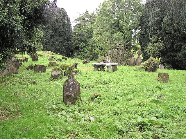
English: Drumragh Graveyard. The tranquil setting of a very ancient graveyard. This old cemetery and ruined church is now the only monument of any great antiquity that links the local parish to pre-reformation times. It is said that the church was demolished by Cromwellian troops who fired their cannon from the present-day Cannonhill area of Omagh. Indeed, local farmers are said to have dug up cannon balls while ploughing nearby fields. (This I find hard to believe as Cannon Hill is several miles away)
It is most likely that the present walls of the ruins mark the site of are the old walls of the ancient Catholic Church which was partly rebuilt in the Plantation period for Protestant worship. Although the native Irish, in the most part, ceased to bury their dead here after the Plantation, Catholics were allowed the right of burial but only under certain conditions. Thus, the priest was not allowed to wear a surplice and crosses were not permitted to be erected on the grave. In 1902 the Board of Guardians forbade the use of this cemetery but later a section was added for the present congregation. Alice Milligan, who was a prominent Gaelic League during the League's heyday in the early 1900s was buried here in 1953. |
| Date | |
| Source | From geograph.org.uk |
| Author | Kenneth Allen |
| Attribution (required by the license) InfoField | Kenneth Allen / Drumragh Graveyard / |
InfoField | Kenneth Allen / Drumragh Graveyard |
| Camera location | 54° 34′ 28″ N, 7° 17′ 59″ W | View this and other nearby images on: OpenStreetMap |
|---|
| Object location | 54° 34′ 28″ N, 7° 17′ 59″ W | View this and other nearby images on: OpenStreetMap |
|---|
Licensing

|
This image was taken from the Geograph project collection. See this photograph's page on the Geograph website for the photographer's contact details. The copyright on this image is owned by Kenneth Allen and is licensed for reuse under the Creative Commons Attribution-ShareAlike 2.0 license.
|
- You are free:
- to share – to copy, distribute and transmit the work
- to remix – to adapt the work
- Under the following conditions:
- attribution – You must give appropriate credit, provide a link to the license, and indicate if changes were made. You may do so in any reasonable manner, but not in any way that suggests the licensor endorses you or your use.
- share alike – If you remix, transform, or build upon the material, you must distribute your contributions under the same or compatible license as the original.
The categories of this image should be checked. Check them now!
This image was uploaded as part of the Geograph batch upload English | suomi | français | galego | עברית | magyar | македонски | മലയാളം | português | português do Brasil | Türkçe | +/− |
Captions
Items portrayed in this file
depicts
some value
30 September 2005
54°34'27.55"N, 7°17'58.56"W
54°34'27.55"N, 7°17'58.56"W
0.03333333333333333333 second
2.8
6.3 millimetre
image/jpeg
File history
Click on a date/time to view the file as it appeared at that time.
| Date/Time | Thumbnail | Dimensions | User | Comment | |
|---|---|---|---|---|---|
| current | 22:03, 30 January 2010 |  | 640 × 479 (190 KB) | GeographBot | == {{int:filedesc}} == {{Information |description={{en|1=Drumragh Graveyard. The tranquil setting of a very ancient graveyard. This old cemetery and ruined church is now the only monument of any great antiquity that links the local parish to pre-reformati |
File usage
The following 3 pages use this file:
Metadata
This file contains additional information, probably added from the digital camera or scanner used to create or digitize it.
If the file has been modified from its original state, some details may not fully reflect the modified file.
| Image title | OLYMPUS DIGITAL CAMERA |
|---|---|
| Camera manufacturer | OLYMPUS CORPORATION |
| Camera model | C750UZ |
| Exposure time | 1/30 sec (0.033333333333333) |
| F-number | f/2.8 |
| ISO speed rating | 59 |
| Date and time of data generation | 07:21, 30 September 2005 |
| Lens focal length | 6.3 mm |
| Orientation | Normal |
| Horizontal resolution | 72 dpi |
| Vertical resolution | 72 dpi |
| Software used | v753u2-86 |
| File change date and time | 14:31, 27 December 2005 |
| Y and C positioning | Co-sited |
| Exposure Program | Creative program (biased toward depth of field) |
| Exif version | 2.2 |
| Date and time of digitizing | 07:21, 30 September 2005 |
| Image compression mode | 2 |
| Exposure bias | 0 |
| Maximum land aperture | 3 APEX (f/2.83) |
| Metering mode | Pattern |
| Light source | Unknown |
| Flash | Flash did not fire, compulsory flash suppression |
| Color space | sRGB |
| Custom image processing | Normal process |
| Exposure mode | Auto exposure |
| White balance | Auto white balance |
| Digital zoom ratio | 0 |
| Scene capture type | Standard |
| Contrast | Normal |
| Saturation | Normal |
| Sharpness | Normal |

