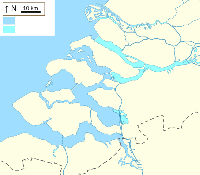
File:Deltawork.PNG
Appearance

Size of this preview: 686 × 599 pixels. Other resolutions: 275 × 240 pixels | 550 × 480 pixels | 879 × 768 pixels | 1,172 × 1,024 pixels | 1,580 × 1,380 pixels.
Original file (1,580 × 1,380 pixels, file size: 220 KB, MIME type: image/png)
File history
Click on a date/time to view the file as it appeared at that time.
| Date/Time | Thumbnail | Dimensions | User | Comment | |
|---|---|---|---|---|---|
| current | 06:55, 11 October 2021 |  | 1,580 × 1,380 (220 KB) | Io Herodotus | tunnel |
| 07:22, 7 October 2015 |  | 1,580 × 1,380 (220 KB) | Io Herodotus | bernisse | |
| 20:44, 6 October 2015 |  | 1,580 × 1,380 (221 KB) | Io Herodotus | spui | |
| 21:42, 24 June 2015 |  | 1,580 × 1,380 (106 KB) | Io Herodotus | Maasvlakte2 Zealand bridge | |
| 14:13, 28 February 2014 |  | 1,580 × 1,380 (214 KB) | Io Herodotus | slight change of colours | |
| 12:56, 28 February 2014 |  | 1,580 × 1,380 (214 KB) | Io Herodotus | fresh water, sea water with a different colour | |
| 10:49, 24 February 2014 |  | 1,580 × 1,380 (213 KB) | Io Herodotus | colours of the lacs and large rivers | |
| 15:08, 20 February 2014 |  | 1,580 × 1,380 (214 KB) | Io Herodotus | colours, border | |
| 13:57, 19 February 2014 |  | 1,580 × 1,500 (223 KB) | Io Herodotus | haringvliet | |
| 10:52, 19 February 2014 |  | 1,580 × 1,500 (223 KB) | Io Herodotus | User created page with UploadWizard |
File usage
The following 10 pages use this file:
Global file usage
The following other wikis use this file:
- Usage on ar.wikipedia.org
- Usage on bn.wikipedia.org
- Usage on fr.wikipedia.org
- Plan Delta
- Oesterdam
- Oosterscheldekering
- Maeslantkering
- Hartelkering
- Veerse Meer
- Markiezaatskade
- Veerse Gat
- Haringvlietdam
- Haringvliet (bras de mer)
- Spui (rivière)
- Hollands Diep (rivière)
- Dordtsche Kil
- Canal de Zuid-Beveland
- Volkerak
- Grevelingenmeer
- Veerse Gatdam
- Philipsdam
- Krammer
- Grevelingendam
- Stormvloedkering Hollandse IJssel
- Zandkreekdam
- Brouwersdam
- Volkerakdam
- Bathse spuisluis
- Zandkreek
- Markiezaatsmeer
- Pont de Zélande
- Écluses du Volkerak
- Pont du Haringvliet
- Hellegatsdam
- Zoommeer
- Modèle:Géolocalisation/Plan Delta
- Modèle:Carte/Plan Delta
- Modèle:Carte/Plan Delta-lacs
- Bernisse (rivière)
- Usage on nl.wikipedia.org
View more global usage of this file.
