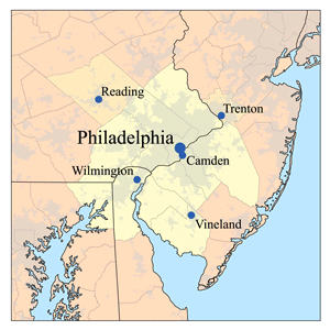
File:Delawarevalleymap.png
Appearance
Delawarevalleymap.png (300 × 300 pixels, file size: 29 KB, MIME type: image/png)
File history
Click on a date/time to view the file as it appeared at that time.
| Date/Time | Thumbnail | Dimensions | User | Comment | |
|---|---|---|---|---|---|
| current | 12:53, 28 August 2006 |  | 300 × 300 (29 KB) | Kmusser | |
| 16:24, 15 May 2006 |  | 250 × 250 (22 KB) | Kmusser | ||
| 20:58, 10 May 2006 |  | 250 × 250 (55 KB) | Kmusser | This is a map of the Delware Valley Metro area I made using U.S. Census Bureau data. |
File usage
The following 3 pages use this file:
Global file usage
The following other wikis use this file:
- Usage on azb.wikipedia.org
- Usage on de.wikipedia.org
- Usage on es.wikipedia.org
- Usage on fa.wikipedia.org
- Usage on fr.wikipedia.org
- Usage on he.wikipedia.org
- Usage on ja.wikipedia.org
- Usage on nl.wikipedia.org
- Usage on simple.wikipedia.org
- Usage on sv.wikipedia.org
- Usage on zh.wikipedia.org


