Jump to content

File:Cricket counties.svg

Page contents not supported in other languages.
This is a file from the Wikimedia Commons
From Wikipedia, the free encyclopedia

Original file (SVG file, nominally 512 × 622 pixels, file size: 276 KB)

Summary

Description
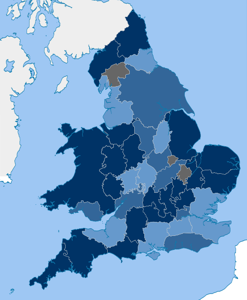
English: Counties of County cricket
Date (UTC)
Source

This file was derived from:

Author


This is a retouched picture, which means that it has been digitally altered from its original version. Modifications: Glamorgan transposed onto the English historic county map. The original can be viewed here: Wales Historical Counties.png. Modifications made by Sceptre.

Licensing

w:en:Creative Commons
attribution share alike
This file is licensed under the Creative Commons Attribution-Share Alike 3.0 Unported license.
You are free:
  • to share – to copy, distribute and transmit the work
  • to remix – to adapt the work
Under the following conditions:
  • attribution – You must give appropriate credit, provide a link to the license, and indicate if changes were made. You may do so in any reasonable manner, but not in any way that suggests the licensor endorses you or your use.
  • share alike – If you remix, transform, or build upon the material, you must distribute your contributions under the same or compatible license as the original.

Original upload log

This image is a derivative work of the following images:

  • File:English counties 1851 with ridings.svg licensed with Cc-by-sa-3.0
    • 2012-03-20T23:09:46Z Dr Greg 1108x1345 (322155 Bytes) correction to status of Ireland in 1851
    • 2012-03-19T20:29:48Z Dr Greg 1108x1345 (325718 Bytes) == {{int:filedesc}} == {{Information |Description={{en|Map showing the [[w:historic counties of England|historical counties of England]] in 1851, excluding the City of London, and including the ridings of Yorkshire. Exclaves
  • File:Wales Historical Counties.png licensed with Cc-by-sa-3.0, GFDL
    • 2010-02-22T21:50:31Z XrysD 2150x2338 (692475 Bytes) Changed Flint to include area of St Asaph, mistakenly part of Denbigh.
    • 2009-11-06T20:06:57Z XrysD 2150x2338 (598910 Bytes) {{Information |Description={{en|1=Map of the historical counties of Wales}} |Source={{own}} |Author=[[User:XrysD|XrysD]] |Date=2009-11-05 |Permission= |other_versions= }}

Uploaded with derivativeFX

Captions

Add a one-line explanation of what this file represents

Items portrayed in this file

depicts

26 April 2018

image/svg+xml

e31a5cdeb77db0ecc7f0eb21524a05ca0db288b1

282,798 byte

622 pixel

512 pixel

File history

Click on a date/time to view the file as it appeared at that time.

Date/TimeThumbnailDimensionsUserComment
current12:35, 27 August 2024Thumbnail for version as of 12:35, 27 August 2024512 × 622 (276 KB)Ytfc23Updated for 2024
19:35, 22 September 2020Thumbnail for version as of 19:35, 22 September 2020512 × 622 (276 KB)Sceptrefor 2021 season
18:17, 14 September 2019Thumbnail for version as of 18:17, 14 September 2019512 × 622 (276 KB)SceptreFixed version
10:15, 14 September 2019Thumbnail for version as of 10:15, 14 September 2019512 × 622 (280 KB)AcabashiReverted to version as of 00:33, 26 April 2018 (UTC) All blacked out map is meaningless, and with no relevance to the added key. The previous versions at least defined county CCs and minor county CCs. from
22:06, 13 September 2019Thumbnail for version as of 22:06, 13 September 2019512 × 622 (280 KB)SceptreDarken colors for accessibility; also reflect end of 2018 season
00:33, 26 April 2018Thumbnail for version as of 00:33, 26 April 2018512 × 622 (280 KB)Sceptre== {{int:filedesc}} == {{Information |Description={{en|Counties of w:County cricket}} |Source={{Derived from|English counties 1851 with ridings.svg|Wales Historical Counties.png|display=50}} |Date=2018-04-26 00:33 (UTC) |Author=* File:English counties 1851 with ridings.svg: *England counties 1851.png: MRSC *English ceremonial counties 2010.svg:...

Global file usage

The following other wikis use this file:

Metadata