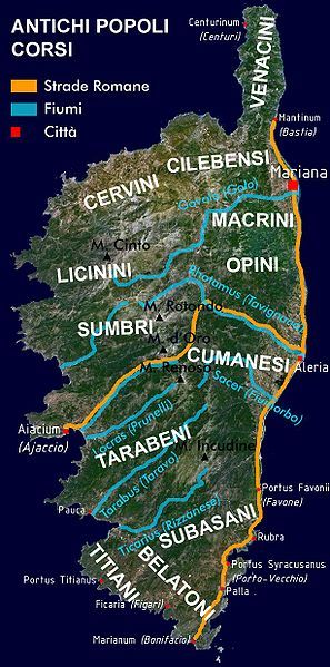
File:Corsica-Romana.jpg
Appearance

Size of this preview: 297 × 599 pixels. Other resolutions: 119 × 240 pixels | 614 × 1,238 pixels.
Original file (614 × 1,238 pixels, file size: 156 KB, MIME type: image/jpeg)
File history
Click on a date/time to view the file as it appeared at that time.
| Date/Time | Thumbnail | Dimensions | User | Comment | |
|---|---|---|---|---|---|
| current | 16:02, 10 November 2007 |  | 614 × 1,238 (156 KB) | Piero Montesacro | {{Information |Description= Simplified Map of Corsica, indicating the geographic distribution of the ancient Corsican Tribes, the main cities and roads in the Roman age. Created by myself based on a satellite image acquired through NASA World Wind 1.3. |S |
File usage
The following 5 pages use this file:
Global file usage
The following other wikis use this file:
- Usage on ca.wikipedia.org
- Usage on eu.wikipedia.org
- Usage on id.wikipedia.org
- Usage on it.wikipedia.org
- Usage on sc.wikipedia.org
- Usage on sl.wikipedia.org
- Usage on zh.wikipedia.org
