File:Coniston view.jpg
Page contents not supported in other languages.
Tools
Actions
General
In other projects
Appearance
Coniston_view.jpg (640 × 321 pixels, file size: 234 KB, MIME type: image/jpeg)
| This is a file from the Wikimedia Commons. Information from its description page there is shown below. Commons is a freely licensed media file repository. You can help. |
Summary
| DescriptionConiston view.jpg |
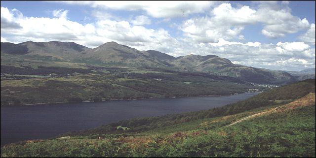
English: View from Great Hill, Selside. View from the great Hill, looking northwards up Coniston Water with the 'Old Man of Coniston' visible on the left. This is a great walk to take in the south of the lakes. You meet virtually no one and after a stiff climb, the views are superb. A good circular route can be started from the small car park in the woods at Crabs Haw (SD297908). We walked down the road from there to High Nibthwaite and then took the path leading up the side of High Wood. Once at the top, you walk round a farm and then onto open moorland heading towards Top o' Selside from where you can pick up a green lane back down to the car park. Wear decent footwear though, it gets boggy in places, even in the summer. |
| Date | |
| Source | From geograph.org.uk |
| Author | Mike Crowe |
| Permission (Reusing this file) |
Creative Commons Attribution Share-alike license 2.0 |
| Object location | 54° 19′ 13″ N, 3° 04′ 16″ W | View this and other nearby images on: OpenStreetMap |
|---|
Licensing

|
This image was taken from the Geograph project collection. See this photograph's page on the Geograph website for the photographer's contact details. The copyright on this image is owned by Mike Crowe and is licensed for reuse under the Creative Commons Attribution-ShareAlike 2.0 license.
|
This file is licensed under the Creative Commons Attribution-Share Alike 2.0 Generic license.
Attribution: Mike Crowe
- You are free:
- to share – to copy, distribute and transmit the work
- to remix – to adapt the work
- Under the following conditions:
- attribution – You must give appropriate credit, provide a link to the license, and indicate if changes were made. You may do so in any reasonable manner, but not in any way that suggests the licensor endorses you or your use.
- share alike – If you remix, transform, or build upon the material, you must distribute your contributions under the same or compatible license as the original.
Captions
View from Great Hill, Selside
12 August 2004
54°19'12.7"N, 3°4'15.6"W
image/jpeg
27c34ad0f32dfc78d31213e4c1c0b6cdc23595bf
239,825 byte
321 pixel
640 pixel
File history
Click on a date/time to view the file as it appeared at that time.
| Date/Time | Thumbnail | Dimensions | User | Comment | |
|---|---|---|---|---|---|
| current | 15:57, 6 June 2007 |  | 640 × 321 (234 KB) | Mark J | {{geograph|12214|Mike Crowe}} |
File usage
The following page uses this file:
Metadata
This file contains additional information, probably added from the digital camera or scanner used to create or digitize it.
If the file has been modified from its original state, some details may not fully reflect the modified file.
| Orientation | Normal |
|---|---|
| Horizontal resolution | 96 dpi |
| Vertical resolution | 96 dpi |
| Software used | Adobe Photoshop 7.0 |
| File change date and time | 19:53, 23 May 2005 |
| Color space | Uncalibrated |
Retrieved from "https://en.wikipedia.org/wiki/File:Coniston_view.jpg"

