Jump to content

File:Comp-rcm.png

Page contents not supported in other languages.
This is a file from the Wikimedia Commons
From Wikipedia, the free encyclopedia

Comp-rcm.png (540 × 496 pixels, file size: 23 KB, MIME type: image/png)

Summary

Description
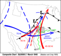
English: Severe weather composite chart to find the triggers for severe thunderstorms: this case is from 26th of March 1948 at 00 GMT. Features are 500-mb features in blue, 850-mb features in red and green, and surface frontal analyses and 60°F dewpoint in black. The wavy green lines indicate moisture axes at 850 mb and the red dotted lines the axes of highest temperatures at 850 mb. Maximum observed wind speeds are indicated; many winds were missing at 500 mb.
Français : Carte composite des éléments déclencheurs favorables au temps violent. Cette carte est celle du 26 mars 1948 à 00 TU selon Maddox et Crisp (1999) du NOAA. Les symboles sont : les flèches en rouge sont les courant-jets à 500 mb, celles en bleu ceux à 850 mb, en noir l'analyse des fronts et de la dépression en surface, en vert l'humidité maximale à 850 mb, la ligne pointée en rouge les plus hautes températures à 850 mb et celle en tiretés représente la ligne orageuse. La valeur maximale des vents est indiquée bien que plusieurs sondages étaient manquants à 500 mb.
Date
Source Storm Prediction Center of NOAA at Storm Prediction Center archive page
Author Maddox and Crisp from NOAA

Licensing

Public domain
This image is in the public domain because it contains materials that originally came from the U.S. National Oceanic and Atmospheric Administration, taken or made as part of an employee's official duties.

العربية  čeština  Deutsch  Zazaki  English  español  eesti  suomi  français  hrvatski  magyar  italiano  日本語  한국어  македонски  മലയാളം  Plattdüütsch  Nederlands  polski  português  română  русский  sicilianu  slovenščina  Türkçe  Tiếng Việt  简体中文  繁體中文  +/−

Original upload log

Date/Time Dimensions User Comment
5 August 2006, 12:13:34 540 × 496 (19032 bytes) Pierre cb (talk · contribs) Carte composite des éléments déclencheurs favorables au temps violent. Cette carte est celle du 26 mars 1948 à 00 TU selon Maddox et Crisp (1999) du NOAA. ============================================================================= Severe weather c

Captions

Add a one-line explanation of what this file represents

Items portrayed in this file

depicts

image/png

4a0c484f20c83507a14cd1836e434e2a63736066

23,747 byte

496 pixel

540 pixel

File history

Click on a date/time to view the file as it appeared at that time.

Date/TimeThumbnailDimensionsUserComment
current22:26, 24 November 2014Thumbnail for version as of 22:26, 24 November 2014540 × 496 (23 KB)GifTaggerBot: Converting file to superior PNG file. (Source: Comp-rcm.gif). This GIF was problematic due to non-greyscale color table.

The following page uses this file:

Global file usage

The following other wikis use this file: