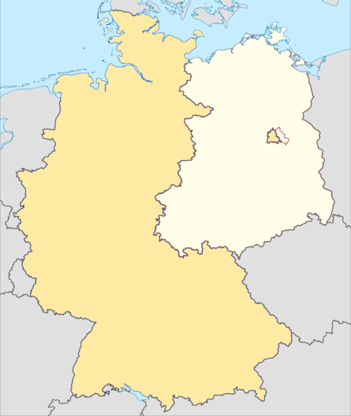
File:Cold War Germany.png
Appearance

Size of this preview: 506 × 599 pixels. Other resolutions: 203 × 240 pixels | 405 × 480 pixels | 649 × 768 pixels | 865 × 1,024 pixels | 2,000 × 2,368 pixels.
Original file (2,000 × 2,368 pixels, file size: 381 KB, MIME type: image/png)
File history
Click on a date/time to view the file as it appeared at that time.
| Date/Time | Thumbnail | Dimensions | User | Comment | |
|---|---|---|---|---|---|
| current | 12:57, 5 December 2011 |  | 2,000 × 2,368 (381 KB) | SreeBot | (Original text) : Remove Saarland border. |
| 12:57, 5 December 2011 |  | 2,000 × 2,368 (386 KB) | SreeBot | (Original text) : Original authors were TUBS and ZyMOS on commons.wikimedia.org, file there is http://commons.wikimedia.org/wiki/File:Germany,_Federal_Republic_of_location_map_January_1957_-_October_1990.svg Derivative work, allowed by Creative Commons A |
File usage
The following 12 pages use this file:
- 11th Armored Cavalry Regiment
- CENTAG wartime structure in 1989
- Fulda Gap
- III Corps (Bundeswehr)
- Museums of the inner German border
- Northern Army Group (1989) order of battle
- User:Noclador/sandbox/CENTAG 1989
- User:Noclador/sandbox/Maps 1989
- User:Noclador/sandbox/NORTHAG 1989
- User talk:Noclador/Archive 10
- Module:Location map/data/Cold War Germany
- Module:Location map/data/Cold War Germany/doc
Global file usage
The following other wikis use this file:
- Usage on ar.wikipedia.org
- Usage on bs.wikipedia.org
- Usage on ceb.wikipedia.org
- Usage on da.wikipedia.org
- Usage on fa.wikipedia.org
- Usage on fr.wikipedia.org
- Usage on kn.wikipedia.org
- Usage on simple.wikipedia.org
- Usage on si.wikipedia.org
- Usage on tg.wikipedia.org
- Usage on tr.wikipedia.org
- Usage on uz.wikipedia.org
- Usage on war.wikipedia.org
- Usage on zh.wikipedia.org
