Jump to content

File:Champ1632 82.jpg

Page contents not supported in other languages.
This is a file from the Wikimedia Commons
From Wikipedia, the free encyclopedia

Original file (1,845 × 1,009 pixels, file size: 936 KB, MIME type: image/jpeg)

Description
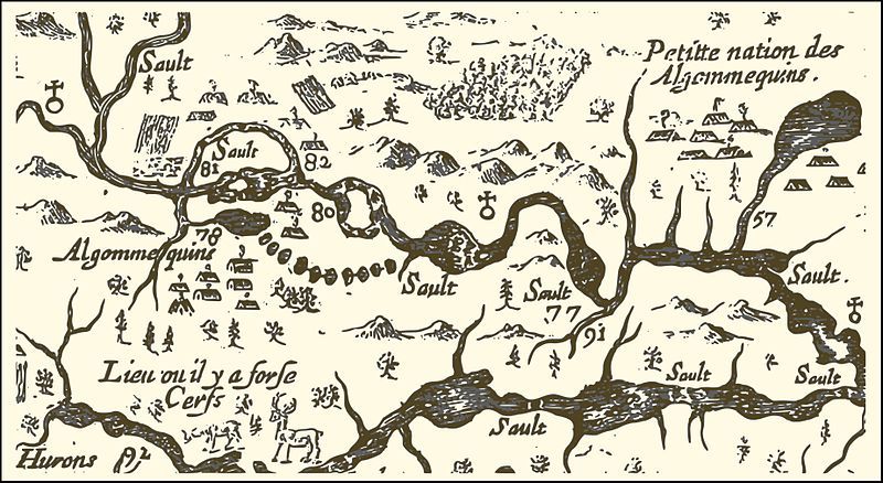
English: An extract from a map of the eastern reaches of New France, showing a portion of the Ottawa River. The map was created in 1632 by Samuel de Champlain to show the route he took in 1616, with numbers used to indicate sites he visisted, significant rapids and aboriginal encampments. In particular,
  • Numbers 77 and 91 correspond to the locations of the modern-day City of Ottawa and the Rideau River respectively;
  • Number 80 marks the location of the large rapids south of Calumet Island;
  • Number 81 shows the site of Allumette Island, inhabited at that time by members of the Algonquin nation;
  • Number 82 corresponds roughly to the location of the modern-day village of Fort-Coulogne, and an Algonquin settlement that existed at the time of Champlain's travels; and
  • To the north, the tree and mountain symbols presumably show the large expanses of pine forest.
Français : Carte de l'est de la Nouvelle-France par Samuel de Champlain (1632) - extrait de la portion de la rivière des Outaouais. Champlain fait graver en France en 1632 une carte de son trajet réalisé en 1616 sur laquelle il indique à l'aide de chiffres, certains sites visités, des saults (rapides) importants ou des campements indiens.
  • La position 77 et 91 correspond respectivement à l'actuel emplacement de la ville d'Ottawa et à la rivière Rideau
  • La position 80 de cette carte indique le lieu des grands rapides situés au sud de l'Île du Grand-Calumet
  • La position 81 indique l'emplacement de l'Île-aux-Allumettes, habité par les Algonquins
  • La position 82 correspond approximativement à l'emplacement de Fort-Coulonge et y indique un campement algonquin
  • Un peu au nord, on note les symboles des montagnes et des arbres indiquant sans doute la présence de forêts de grands pins
Date
Source http://gallica.bnf.fr/ark:/12148/btv1b6700076h/
Author Samuel de Champlain
Permission
(Reusing this file)
Previous public domain rationale, no longer applicable
Public domain

العربية  Deutsch  English  español  français  galego  italiano  日本語  македонски  Nederlands  português  русский  sicilianu  slovenščina  українська  +/−

Captions

Add a one-line explanation of what this file represents

Items portrayed in this file

depicts

image/jpeg

00ca34f2112c2309db06fa71f2e4bd66fffd0878

958,696 byte

1,009 pixel

1,845 pixel

File history

Click on a date/time to view the file as it appeared at that time.

Date/TimeThumbnailDimensionsUserComment
current04:20, 31 August 2016Thumbnail for version as of 04:20, 31 August 20161,845 × 1,009 (936 KB)Pierre5018vectorisation et conversion png
03:07, 31 August 2016Thumbnail for version as of 03:07, 31 August 2016888 × 482 (152 KB)Pierre5018nouvelle source: Gallica ark:/12148/btv1b6700076h
01:21, 7 January 2007Thumbnail for version as of 01:21, 7 January 20071,006 × 497 (170 KB)JljmtCarte de l'est de la Nouvelle-France par Samuel de Champlain 1632 extrait de la portion de la rivière des Outaouais
23:50, 6 January 2007Thumbnail for version as of 23:50, 6 January 20071,006 × 497 (171 KB)JljmtCarte de l'est de la Nouvelle-France par Samuel de Champlain 1632 extrait de la portion de la rivière des Outaouais

The following page uses this file:

Global file usage

The following other wikis use this file:

Metadata