Jump to content

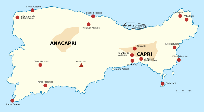
File:Capri sights.svg

Page contents not supported in other languages.
This is a file from the Wikimedia Commons
From Wikipedia, the free encyclopedia

Original file (SVG file, nominally 1,000 × 550 pixels, file size: 56 KB)

Summary

Description
English: Map of Capri
Italiano: Mapa de la isla de Capri (Italia)


Note: An offical map of Capri (with roads, etc.) can be found at http://www.capritourism.com/imgg/download/capri_map_en.pdf

Note: An improved version is available: File:Capri sights.png
Date
Source http://en.wikipedia.org/wiki/Image:Capri_sights.svg
Author en:User: Morn
Other versions
PNG version of new SVG

Licensing

GNU head Permission is granted to copy, distribute and/or modify this document under the terms of the GNU Free Documentation License, Version 1.2 or any later version published by the Free Software Foundation; with no Invariant Sections, no Front-Cover Texts, and no Back-Cover Texts. A copy of the license is included in the section entitled GNU Free Documentation License.
w:en:Creative Commons
attribution share alike
This file is licensed under the Creative Commons Attribution-Share Alike 3.0 Unported license.
You are free:
  • to share – to copy, distribute and transmit the work
  • to remix – to adapt the work
Under the following conditions:
  • attribution – You must give appropriate credit, provide a link to the license, and indicate if changes were made. You may do so in any reasonable manner, but not in any way that suggests the licensor endorses you or your use.
  • share alike – If you remix, transform, or build upon the material, you must distribute your contributions under the same or compatible license as the original.
This licensing tag was added to this file as part of the GFDL licensing update.

Captions

Add a one-line explanation of what this file represents

Items portrayed in this file

depicts

5 July 2006

image/svg+xml

4b2d2ac24032f28fcdeb5a6db1ab4e3c45e177e3

57,182 byte

550 pixel

1,000 pixel

File history

Click on a date/time to view the file as it appeared at that time.

Date/TimeThumbnailDimensionsUserComment
current17:55, 2 April 2010Thumbnail for version as of 17:55, 2 April 20101,000 × 550 (56 KB)User A1Less lopsided label
17:54, 2 April 2010Thumbnail for version as of 17:54, 2 April 20101,000 × 550 (56 KB)User A1Fix SVG rendering problem
11:30, 2 April 2010Thumbnail for version as of 11:30, 2 April 20101,000 × 550 (55 KB)Mornstandard map colors
10:56, 2 April 2010Thumbnail for version as of 10:56, 2 April 20101,000 × 550 (59 KB)MornReverted to version as of 19:35, 11 March 2009---actually, Monte Solaro is also rendered wrong in the old version, so reverting revert
10:55, 2 April 2010Thumbnail for version as of 10:55, 2 April 20101,000 × 550 (60 KB)MornReverted to version as of 20:52, 14 July 2007 because "Monte Solaro" looked all screwed up in the Wikimedia SVG renderer
19:35, 11 March 2009Thumbnail for version as of 19:35, 11 March 20091,000 × 550 (59 KB)HomoPediaAdded the Capri Philosophical Park.
20:52, 14 July 2007Thumbnail for version as of 20:52, 14 July 20071,000 × 550 (60 KB)Dorieo21{{Information |Description=Mapa de la isla de Capri (Italia) |Source=http://en.wikipedia.org/wiki/Image:Capri_sights.svg |Date=5 julio 2006 |Author= en:User: Morn |Permission= |other_versions= }} Category:Naples
No pages on the English Wikipedia use this file (pages on other projects are not listed).