Jump to content

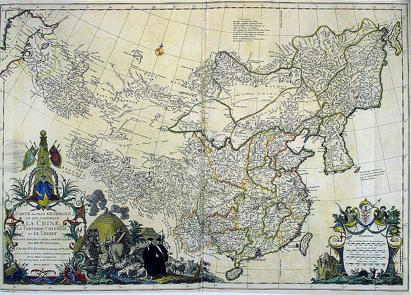
File:CEM-44-La-Chine-la-Tartarie-Chinoise-et-le-Thibet-1734-2568.jpg

Page contents not supported in other languages.
This is a file from the Wikimedia Commons
From Wikipedia, the free encyclopedia

Original file (2,552 × 1,832 pixels, file size: 2.5 MB, MIME type: image/jpeg)

Info

Description
Français : Carte la plus generale et qui comprend la Chine, la Tartarie Chinoise, et le Thibet. Dressee sur les cartes particuliers des RR PP Jesuites, par le Sr. d'Anville..., qui ya joint le pays compris entre Kashgar et la mar Caspienne, tire des geographes et des historiens orientaux
English: A most general map, including China, Chinese Tartary, and Tibet, based on individual maps of the Jesuit fathers. The map gives 1734 as the year, but the modern HKUST publishers say 1737
English: Entire map

"D’Anville’s maps of China were based on a survey of the Chinese empire that was ordered by the emperor in 1708 and carried out by the Chinese, but under the supervision of Jesuit priests resident in China. The detail about the interior of China was far superior to any previous Western map or atlas. D’Anville’s work remained a standard Western source for the geography of China and adjacent regions until well into the 19th century, when it finally was superseded by more accurate maps." — (World Digital Library)

中文:清廷于1708年组织在华法国传教士蒋友仁等进行大规模大地测量,以经纬为基础,测绘编成《皇兴全览图》。该图编成后,被视为珍秘,秘藏大内,而其资料宝已流入欧洲,法国皇家地理官唐维尔(D’anville)编辑,于1737年将皇兴全览图出版,经增补修订,改名《中国新地图集》即此书。故此书是康熙时中国大地测量后最早公开的成果,包括彩印总图两幅,分省图十五幅,边外二十五幅,计42幅。此书羊此装,纸张为带徽记的水印纸印刷。
Date 1734, according to the map itself (although the modern publishers say 1737)
Source
English: An antique map from the Special Collection "China in Maps" of the Hong Kong University of Science and Technology Library, reproduced by the HKUST Library in the book "China in European Maps", Hong Kong, 2003. ISBN 962-86403-9-9.
中文:一幅古代的地图从香港科技大学图书馆 ( 地圖中國 - 圖書館特藏展). 在书"China in European Maps", 香港, 2003. ISBN 962-86403-9-9.
Русский: Старинная карта из специальной коллекции Библиотеки Гонконгского научно-технического университета. Опубликована этой библиотекой в книге "China in European Maps" (Китай на европейских картах), Гонконг, 2003. ISBN 962-86403-9-9, тиражом 1000 экз. См. также каталог выставки, Special Collection "China in Maps".
Plate 44
Author
Jean Baptiste Bourguignon d'Anville  (1697–1782)  wikidata:Q733907 s:en:Author:Jean Baptiste Bourguignon d'Anville q:it:Jean-Baptiste Bourguignon d'Anville
 
Jean Baptiste Bourguignon d'Anville
Description French geographer and cartographer
Date of birth/death 11 July 1697 Edit this at Wikidata 28 January 1782 Edit this at Wikidata
Location of birth/death Paris Edit this at Wikidata Paris Edit this at Wikidata
Work location
Authority file
creator QS:P170,Q733907
Permission
(Reusing this file)
Author died more than 70 years ago - public domain
Other versions

Halves

Quarters

Regional Maps

Public domain

This work is in the public domain in its country of origin and other countries and areas where the copyright term is the author's life plus 100 years or fewer.


You must also include a United States public domain tag to indicate why this work is in the public domain in the United States.
This file has been identified as being free of known restrictions under copyright law, including all related and neighboring rights.

Captions

Add a one-line explanation of what this file represents

Items portrayed in this file

depicts

image/jpeg

e35ab1195bf1b753a2048ec4bd0a7d05ee3a6e56

2,619,397 byte

1,832 pixel

2,552 pixel

File history

Click on a date/time to view the file as it appeared at that time.

Date/TimeThumbnailDimensionsUserComment
current13:54, 30 November 2010Thumbnail for version as of 13:54, 30 November 20102,552 × 1,832 (2.5 MB)PawełMMperspective & color enhanced
13:31, 22 March 2009Thumbnail for version as of 13:31, 22 March 20092,560 × 1,920 (2.1 MB)Vmenkov{{Information |Description={{fr|Carte la plus generale et qui comprend la Chine, la Tartarie Chinoise, et le Thibet. Dressee sur les cartes particuliers des RR PP Jesuites, par le Sr. d'Anville..., qui ya joint le pays compris entre Kashgar et la mar Casp

Global file usage

The following other wikis use this file:

Metadata