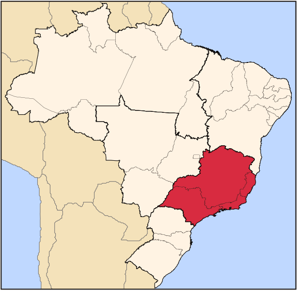
File:Brazil Region Sudeste.svg
Appearance

Size of this PNG preview of this SVG file: 613 × 600 pixels. Other resolutions: 245 × 240 pixels | 490 × 480 pixels | 785 × 768 pixels | 1,046 × 1,024 pixels | 2,093 × 2,048 pixels | 702 × 687 pixels.
Original file (SVG file, nominally 702 × 687 pixels, file size: 442 KB)
File history
Click on a date/time to view the file as it appeared at that time.
| Date/Time | Thumbnail | Dimensions | User | Comment | |
|---|---|---|---|---|---|
| current | 23:24, 11 September 2022 |  | 702 × 687 (442 KB) | Heitordp | Updated border between Acre and Amazonas |
| 09:28, 25 April 2006 |  | 702 × 687 (448 KB) | Raphael.lorenzeto | {{Information| |Description=Map locator of Brazil's Sudeste region |Source=own work |Date=April, 21 2006 |Author=Raphael Lorenzeto de Abreu |Permission={{self2|GFDL|cc-by-2.5}} |other_versions= }} Category:Maps of Brazil |
File usage
The following 3 pages use this file:
Global file usage
The following other wikis use this file:
- Usage on az.wikipedia.org
- Usage on bg.wikipedia.org
- Usage on bpy.wikipedia.org
- Usage on da.wikipedia.org
- Usage on de.wikipedia.org
- Usage on el.wikivoyage.org
- Usage on eo.wikipedia.org
- Usage on es.wikipedia.org
- Usage on et.wikipedia.org
- Usage on fa.wikipedia.org
- Usage on fi.wikipedia.org
- Usage on frr.wikipedia.org
- Usage on fr.wikipedia.org
- Usage on io.wikipedia.org
- Usage on ka.wikipedia.org
- Usage on lt.wikipedia.org
- Usage on mk.wikipedia.org
- Usage on nl.wikipedia.org
- Usage on oc.wikipedia.org
- Usage on pt.wikipedia.org
- Belo Horizonte
- Espírito Santo (estado)
- Minas Gerais
- Rio de Janeiro (estado)
- São Paulo (estado)
- Vitória (Espírito Santo)
- Sorocaba
- Três Corações
- Uberlândia
- Guaratinguetá
- Cruzeiro (São Paulo)
- Guarujá
- Queluz (São Paulo)
- Wikipédia Discussão:Projetos/Países/Brasil/Arquivo/1
- Aparecida (São Paulo)
- Apiaí
- Araxá
- Brumadinho
- Caratinga
- Curvelo
- Divinópolis
- Governador Valadares
- Poços de Caldas
View more global usage of this file.


