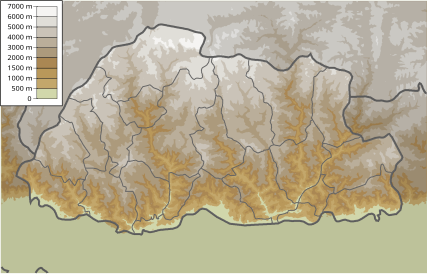
File:Bhutan physical map.svg
Appearance

Size of this PNG preview of this SVG file: 427 × 273 pixels. Other resolutions: 320 × 205 pixels | 640 × 409 pixels | 1,024 × 655 pixels | 1,280 × 818 pixels | 2,560 × 1,637 pixels.
Original file (SVG file, nominally 427 × 273 pixels, file size: 468 KB)
File history
Click on a date/time to view the file as it appeared at that time.
| Date/Time | Thumbnail | Dimensions | User | Comment | |
|---|---|---|---|---|---|
| current | 18:15, 18 February 2011 |  | 427 × 273 (468 KB) | Urutseg | {{Information |Description ={{en|1=Physical map of Bhutan. Parameterw equal to File:Bhutan location map.svg}} |Source ={{own}} |Author =Urutseg |Date = |Permission = |other_versions = }} [[Category:M |
File usage
The following 3 pages use this file:
Global file usage
The following other wikis use this file:
- Usage on ca.wikipedia.org
- Usage on de.wikipedia.org
- Usage on eo.wikipedia.org
- Usage on fa.wikipedia.org
- Usage on hi.wikipedia.org
- Usage on hr.wikipedia.org
- Usage on ilo.wikipedia.org
- Usage on ja.wikipedia.org
- Usage on ku.wikipedia.org
- Usage on mai.wikipedia.org
- Usage on ml.wikipedia.org
- Usage on ms.wikipedia.org
- Usage on ne.wikipedia.org
- Usage on or.wikipedia.org
- Usage on ru.wikipedia.org
- Тхимпху
- Категория:География Бутана
- География Бутана
- Административное деление Бутана
- Города Бутана
- Проект:Тематическая неделя/Гималайская неделя
- Охраняемые природные территории Бутана
- Проект:Бутан
- Реки Бутана
- Список млекопитающих Бутана
- Список птиц Бутана
- Список экорегионов Бутана
- Перевалы Бутана
- Время в Бутане
- Список жужелиц Бутана
- Дуары
- Шаблон:География Бутана
View more global usage of this file.
