Jump to content

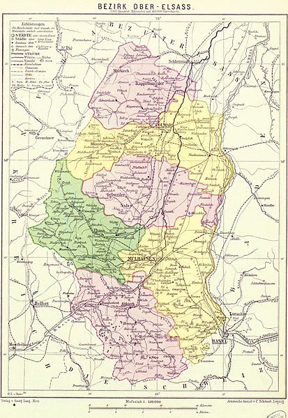
File:Bezirk Ober-Elsaß (Karte).jpg

Page contents not supported in other languages.
This is a file from the Wikimedia Commons
From Wikipedia, the free encyclopedia

Original file (2,424 × 3,520 pixels, file size: 1.64 MB, MIME type: image/jpeg)

Summary

Description
Deutsch: Karte des Bezirks Ober-Elsass
Français : Carte du Bezirk (département) de Haute-Alsace (Haut-Rhin)
Date
Source Georg Langs Mittelschul-Atlas für Elsass-Lothringen mit besonderer Berücksichtigung der Heimat-und Vaterlandskunde..., Gebweiler : J. Boltze, 1890, 32 p. (Bibliothèque nationale et universitaire de Strasbourg)
Author Johann Ludwig Algermissen ; Kartographische Verlagsanstalt von Georg Lang (Metz) ; Artistische Anstalt v. C. Scönert (Leipzig)

Licensing

Licence Ouverte This file is licensed under the Licence Ouverte 1.0 (License text, English license text).

Captions

Add a one-line explanation of what this file represents

Items portrayed in this file

depicts

image/jpeg

d470418ec21a180d70db391b47f7783578662b2b

1,722,297 byte

3,520 pixel

2,424 pixel

File history

Click on a date/time to view the file as it appeared at that time.

Date/TimeThumbnailDimensionsUserComment
current18:46, 4 April 2012Thumbnail for version as of 18:46, 4 April 20122,424 × 3,520 (1.64 MB)Paralacresans les marges
17:59, 4 April 2012Thumbnail for version as of 17:59, 4 April 20122,912 × 4,038 (1.69 MB)Paralacre

The following page uses this file:

Global file usage

The following other wikis use this file:

Metadata

Devtools
Installation completed

Devtools is now enabled.

While getting ready, it missed the HTTP request for this page and related assets. Do you want to reload the page to start again?