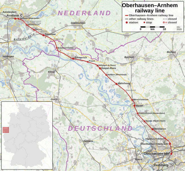
File:Bahnstrecke Oberhausen–Arnhem Karte.svg
Appearance

Size of this PNG preview of this SVG file: 649 × 599 pixels. Other resolutions: 260 × 240 pixels | 520 × 480 pixels | 832 × 768 pixels | 1,109 × 1,024 pixels | 2,218 × 2,048 pixels | 1,381 × 1,275 pixels.
Original file (SVG file, nominally 1,381 × 1,275 pixels, file size: 17.76 MB)
File history
Click on a date/time to view the file as it appeared at that time.
| Date/Time | Thumbnail | Dimensions | User | Comment | |
|---|---|---|---|---|---|
| current | 11:08, 2 May 2021 |  | 1,381 × 1,275 (17.76 MB) | Hbf878 | +Velperpoort |
| 02:21, 18 January 2021 |  | 1,381 × 1,275 (17.76 MB) | Hbf878 | implemented multilanguage | |
| 16:33, 8 December 2020 |  | 1,381 × 1,275 (17.75 MB) | Hbf878 | fix path glitch | |
| 16:00, 27 November 2020 |  | 1,381 × 1,275 (17.19 MB) | Hbf878 | +Betuwe | |
| 12:52, 27 November 2020 |  | 1,381 × 1,275 (17.75 MB) | Hbf878 | <use> fix 2 | |
| 12:51, 27 November 2020 |  | 1,381 × 1,275 (16.56 MB) | Hbf878 | <use> fix | |
| 03:17, 27 November 2020 |  | 1,381 × 1,275 (17.74 MB) | Hbf878 | Uploaded a work by {{U|Hbf878}}, OpenStreetMap contributors, {{U|David Liuzzo}} from {{own}}, using OpenStreetMap data and File:Deutschland_Lage_von_Schleswig-Holstein.svg by David Liuzzo with UploadWizard |
File usage
The following page uses this file:
Global file usage
The following other wikis use this file:
- Usage on de.wikipedia.org
- Usage on hu.wikipedia.org
- Usage on ja.wikipedia.org
- Usage on www.wikidata.org

